IMAGES TAKEN NEAR TO
Reardon Path, LONDON, E1W 2PF
Introduction
This page details the photographs taken nearby to Reardon Path, E1W 2PF by members of the Geograph project.
The Geograph project started in 2005 with the aim of publishing, organising and preserving representative images for every square kilometre of Great Britain, Ireland and the Isle of Man.

There are currently over 7.5m images from over14,400 individuals and you can help contribute to the project by visiting https://www.geograph.org.uk
Image Map
Images are licensed for reuse under creativecommons.org/licenses/by-sa/2.0
Notes
- Clicking on the map will re-center to the selected point.
- The higher the marker number, the further away the image location is from the centre of the postcode.
Image Listing (677 Images Found)
Images are licensed for reuse under creativecommons.org/licenses/by-sa/2.0
Image
Details
Distance
1
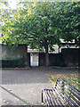
Gate on the west side of Wapping Rose Gardens
The view is to the service area at the rear of Vancouver House Image
Image: © Robin Stott
Taken: 13 Oct 2018
0.01 miles
2
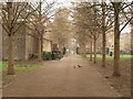
Waterside Gardens, Wapping
Only pigeons in occupation on a damp day. A view from Wapping High Street, with a path leading across past seats to Green Bank.
Image: © Derek Harper
Taken: 1 Feb 2011
0.01 miles
3
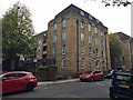
Vancouver House flats by Green Bank, Wapping
Flats built by the London County Council – see the badge at first floor facing the street – and first clearly shown on a map of 1948. It is mirrored by Willoughby House, right, on the other side of Reardon Path. They replaced streets of terraced housing.
Image: © Robin Stott
Taken: 13 Oct 2018
0.01 miles
4
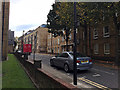
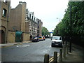
Reardon Path, Wapping
The name must be a postwar invention. It runs through to Wapping High Street. The building nearest across the road is Willoughby House, flats built by London County Council, a near match to Vancouver House Image, just getting into the picture, left.
Image: © Robin Stott
Taken: 13 Oct 2018
0.01 miles
7
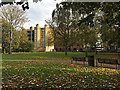
Wapping Rose Gardens
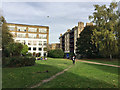
A pleasant and peaceful green space on a sunny Saturday afternoon in October, with little disturbance from Wapping High Street and its police station, right. There are a few roses. In the postwar period this was Waterside Gardens; it has been remodelled since. Before the war this was densely occupied by a cooperage (barrel-maker), dwellings and a school. Partially seen on the left, a late 19th-century tenement called Tower Buildings. There is another surviving example in Brewhouse Lane. The view is from near the Green Bank entrance.
Image: © Robin Stott
Taken: 13 Oct 2018
0.03 miles
8
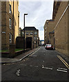
Dundee Street, Wapping
From Green Bank near the camera to Wapping High Street
Image: © Robin Stott
Taken: 13 Oct 2018
0.03 miles
10
Passing time in Wapping Rose Gardens
This pleasant open space between Green Bank and Wapping High Street was called Riverside Gardens in the postwar years. Friends enjoy the October sunshine – Wapping seems full of young people. Chimney Court, left, is a former soap factory converted to flats. Tower Buildings, right, is a tenement surviving from 1864. The thing in the sky must be a plastic bag – it was a breezy day.
Image: © Robin Stott
Taken: 13 Oct 2018
0.04 miles