IMAGES TAKEN NEAR TO
Dock Street, LONDON, E1 8NA
Introduction
This page details the photographs taken nearby to Dock Street, E1 8NA by members of the Geograph project.
The Geograph project started in 2005 with the aim of publishing, organising and preserving representative images for every square kilometre of Great Britain, Ireland and the Isle of Man.

There are currently over 7.5m images from over14,400 individuals and you can help contribute to the project by visiting https://www.geograph.org.uk
Image Map
Images are licensed for reuse under creativecommons.org/licenses/by-sa/2.0
Notes
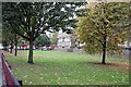
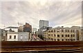
- Clicking on the map will re-center to the selected point.
- The higher the marker number, the further away the image location is from the centre of the postcode.
Image Listing (424 Images Found)
Images are licensed for reuse under creativecommons.org/licenses/by-sa/2.0
Image
Details
Distance
2
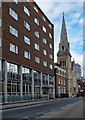
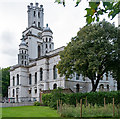
Former St Paul's Church for Seamen, Dock Street
" ... St Paul's Church (Church of England), 1846-7. Architect Henry Roberts. Early English style. Stock brick with stone dressings. Western tower and spire. Replaced the Episcopal Floating Church and was built as a Seamen's Church. Foundation stone laid by Prince Consort." - extracted from this https://historicengland.org.uk/listing/the-list/list-entry/1356656. Closed for worship in 1990.
Image: © Jim Osley
Taken: 16 Sep 2017
0.03 miles
3
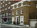
Dock Street, Whitechapel
No 11, originally the vicarage for the adjacent St Paul's church, was designed by Henry Roberts and built by Sir William Cubitt in 1847. It adds a touch of elegance to an otherwise drab area and is grade II listed.
Image: © Stephen McKay
Taken: 25 Jul 2008
0.03 miles
4
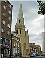
Dock Street, Whitechapel
St Paul's church dominates the street, although it ceased to be used as a church in 1990 and is now a children's nursery. The elegant house to the left of it, no 11, is late Georgian and was designed by Henry Roberts as the vicarage for St Paul's.
Image: © Stephen McKay
Taken: 25 Jul 2008
0.03 miles
6
Dock Street
View along Dock Street from the Docklands Light Railway.
Image: © Alan Hughes
Taken: 24 Jun 2022
0.03 miles
7
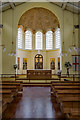
Interior, St George-in-the-East
Interior view a church built within the shell of Nicholas Hawksmoor's bomb-damaged St George-in-the-East. Built in the early 1960s to a design by architects Ansell & Bailey.
Image: © Jim Osley
Taken: 16 Sep 2017
0.04 miles
8
Church of St George-in-the-East, Tower Hamlets
A Nicholas Hawksmoor church, built between 1714 and 1729. Gutted in World War II. Interior reconstructed between 1960 and 1964. Grade I listed, description at this https://historicengland.org.uk/listing/the-list/list-entry/1357779.
Image: © Jim Osley
Taken: 16 Sep 2017
0.04 miles
9

Cable Street
These buildings are at the junction of Cable St and Royal Mint St in the East End of London. Cable St was the site of a turning point in British history when on the 4th of October 1936 the ordinary working people of the East End stood up to Oswald Mosley in the “Battle of Cable St”. A coalition of workers trades unionists and the Jewish population of the area dealt the British Union of Fascists a blow that was not fatal but permanently damaging to their cause. This photo shows some of the few buildings in the area that survive from that time. This was the symbolic beginning of the fight against fascism in the U.K a fight that has never been fully won as the existence of extreme right wing racist political parties attests. The photograph was taken on the 70th anniversary of the “battle” a history can be found at http://www.whatnextjournal.co.uk/Pages/History/Cable.html
Image: © Glyn Baker
Taken: 4 Oct 2006
0.04 miles
