IMAGES TAKEN NEAR TO
Dock Street, LONDON, E1 8BA
Introduction
This page details the photographs taken nearby to Dock Street, E1 8BA by members of the Geograph project.
The Geograph project started in 2005 with the aim of publishing, organising and preserving representative images for every square kilometre of Great Britain, Ireland and the Isle of Man.

There are currently over 7.5m images from over14,400 individuals and you can help contribute to the project by visiting https://www.geograph.org.uk
Image Map
Images are licensed for reuse under creativecommons.org/licenses/by-sa/2.0
Notes
- Clicking on the map will re-center to the selected point.
- The higher the marker number, the further away the image location is from the centre of the postcode.
Image Listing (416 Images Found)
Images are licensed for reuse under creativecommons.org/licenses/by-sa/2.0
Image
Details
Distance
2
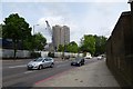
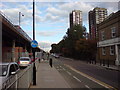
The Highway
Looking east along the A1203 leading towards Limehouse.
Image: © DS Pugh
Taken: 21 May 2016
0.04 miles
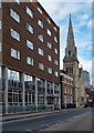
3
Dock Street, Whitechapel
St Paul's church dominates the street, although it ceased to be used as a church in 1990 and is now a children's nursery. The elegant house to the left of it, no 11, is late Georgian and was designed by Henry Roberts as the vicarage for St Paul's.
Image: © Stephen McKay
Taken: 25 Jul 2008
0.05 miles
6
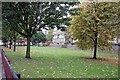
St George-in-the-East, London E1 - East end
Image: © John Salmon
Taken: 14 Oct 2008
0.06 miles
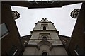
7
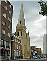
Former St Paul's Church for Seamen, Dock Street
" ... St Paul's Church (Church of England), 1846-7. Architect Henry Roberts. Early English style. Stock brick with stone dressings. Western tower and spire. Replaced the Episcopal Floating Church and was built as a Seamen's Church. Foundation stone laid by Prince Consort." - extracted from this https://historicengland.org.uk/listing/the-list/list-entry/1356656. Closed for worship in 1990.
Image: © Jim Osley
Taken: 16 Sep 2017
0.06 miles
8
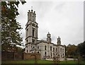
St George-in-the-East, London E1 - Tower
Image: © John Salmon
Taken: 14 Oct 2008
0.06 miles
9
Cable Street, E1
Near the junction with Back Church Lane. This is a favoured route for cycle commuters, heading east out of the city but staying off parallel but very busy main roads, namely Commercial Road (A13) or The Highway (A1203). There is a Docklands Light Railway train on the viaduct.
Image: © Danny P Robinson
Taken: 16 Sep 2009
0.06 miles
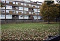
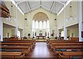
10
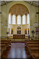
Interior, St George-in-the-East
Interior view a church built within the shell of Nicholas Hawksmoor's bomb-damaged St George-in-the-East. Built in the early 1960s to a design by architects Ansell & Bailey.
Image: © Jim Osley
Taken: 16 Sep 2017
0.06 miles