IMAGES TAKEN NEAR TO
Clarendon Road, LONDON, E17 9AY
Introduction
This page details the photographs taken nearby to Clarendon Road, E17 9AY by members of the Geograph project.
The Geograph project started in 2005 with the aim of publishing, organising and preserving representative images for every square kilometre of Great Britain, Ireland and the Isle of Man.

There are currently over 7.5m images from over14,400 individuals and you can help contribute to the project by visiting https://www.geograph.org.uk
Image Map (Loading...)


Getting Data...Please wait
Leaflet Map data © OpenStreetMap
Images are licensed for reuse under creativecommons.org/licenses/by-sa/2.0
Notes
- Clicking on the map will re-center to the selected point.
- The higher the marker number, the further away the image location is from the centre of the postcode.
Image Listing (59 Images Found)
Images are licensed for reuse under creativecommons.org/licenses/by-sa/2.0
Image
Details
Distance
1
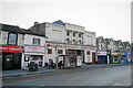
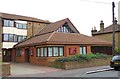
Kingsway International Christian Centre
Operating in a former cinema.
Image: © Bill Boaden
Taken: 17 Mar 2016
0.11 miles
2
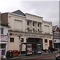
Kingsway International Christian Centre, Walthamstow
Grade II listed former Empress Cinema now church on Hoe Street.
See http://www.britishlistedbuildings.co.uk/en-468679-former-empress-cinema-greater-london-aut for more details about the former cinema.
Image: © David Anstiss
Taken: 10 Mar 2013
0.11 miles
3
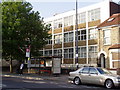
Coppermill (Walthamstow) Telephone Exchange in Hoe Street Walthamstow
Coppermill exchange was originally opened in 1954 and was originally housed at Leytonstone Exchange in Jesse Road Leyton. It was transferred to this new exchange in Hoe Street on 4th September 1958.
Image: © Richard Dunn
Taken: 30 Aug 2008
0.13 miles
6
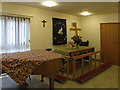
St Stephen, Copeland Road, London E17 - Altar
Image: © John Salmon
Taken: 23 Nov 2004
0.13 miles
7

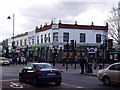
Baker's Arms
Looking the other way along Lea Bridge Road from Image towards Baker's Arms traffic lights.
Image: © Derek Harper
Taken: 18 Nov 2010
0.13 miles
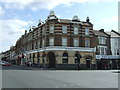
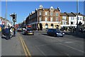
8
Bakers Arms Leyton
What was the "Bakers Arms" pub on the North West corner of Lea Bridge Road and Hoe Street Leyton. The building is now a betting office.
Image: © Richard Dunn
Taken: 14 Feb 2011
0.13 miles
10
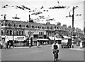
London (Waltham Forest), 1955: Leyton, Baker's Arms intersection
With High Road, Leyton (A112) behind, we are looking across Lea Bridge Road (A104), going off to the left NE towards Walthamstow, Hoe Street. Note the forest of overhead cables, for the numerous trolley-buses operating here in those days - 60 years ago. (Cf. Image).
Image: © Ben Brooksbank
Taken: 13 Jul 1955
0.14 miles