IMAGES TAKEN NEAR TO
E16 4RD
Introduction
This page details the photographs taken nearby to E16 4RD by members of the Geograph project.
The Geograph project started in 2005 with the aim of publishing, organising and preserving representative images for every square kilometre of Great Britain, Ireland and the Isle of Man.

There are currently over 7.5m images from over14,400 individuals and you can help contribute to the project by visiting https://www.geograph.org.uk
Image Map
Images are licensed for reuse under creativecommons.org/licenses/by-sa/2.0
Notes
- Clicking on the map will re-center to the selected point.
- The higher the marker number, the further away the image location is from the centre of the postcode.
Image Listing (84 Images Found)
Images are licensed for reuse under creativecommons.org/licenses/by-sa/2.0
Image
Details
Distance
1
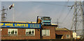
Skip hire firm, Canning Town
The question is, could that skip get any higher? Admittedly it's not a very high building ... Nor is this a good place to work if you are concerned about the effect of magnetic fields from electricity pylons. Seen from the DLR.
Image: © Derek Harper
Taken: 17 Apr 2019
0.10 miles
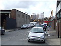
2
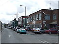
Stephenson Street, Canning Town
Stephenson Street looking south to Canning Town.
Image: © Malc McDonald
Taken: 2 Oct 2010
0.10 miles
3
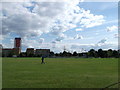
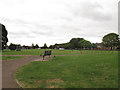
Star Lane Park
As seen from Star Lane, looking across the park towards Canning town.
Image: © David Anstiss
Taken: 26 Aug 2012
0.11 miles
4
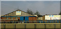
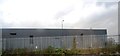
Building products firm, Canning Town
Seen from the DLR.
Image: © Derek Harper
Taken: 17 Apr 2019
0.11 miles
6
Jubilee Line train passes Star Lane DLR station, light fading
Image: © Christopher Hilton
Taken: 4 Feb 2014
0.12 miles
7
Ives Road, Canning Town
Ives Road, near Canning Town.
Image: © Malc McDonald
Taken: 2 Oct 2010
0.12 miles
8
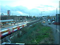
View south from Star Lane DLR station
In the distance, a Docklands Light Railway train heads south to Canning Town after calling at Star Lane; to the right of it the tracks of the Jubilee Line.
Image: © Christopher Hilton
Taken: 4 Feb 2014
0.13 miles
9
Star Park, Newham
A small urban park.
Image: © Stephen Craven
Taken: 15 Jun 2014
0.14 miles
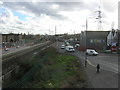
10
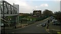
Looking east from Star Lane DLR station
The road approaching the camera, with the car stopped at traffic lights, is Star Lane, from which the Docklands Light Railway station takes its name.
Image: © Christopher Hilton
Taken: 8 Apr 2015
0.15 miles