IMAGES TAKEN NEAR TO
Clarence Road, LONDON, E16 4QY
Introduction
This page details the photographs taken nearby to Clarence Road, E16 4QY by members of the Geograph project.
The Geograph project started in 2005 with the aim of publishing, organising and preserving representative images for every square kilometre of Great Britain, Ireland and the Isle of Man.

There are currently over 7.5m images from over14,400 individuals and you can help contribute to the project by visiting https://www.geograph.org.uk
Image Map
Images are licensed for reuse under creativecommons.org/licenses/by-sa/2.0
Notes
- Clicking on the map will re-center to the selected point.
- The higher the marker number, the further away the image location is from the centre of the postcode.
Image Listing (41 Images Found)
Images are licensed for reuse under creativecommons.org/licenses/by-sa/2.0
Image
Details
Distance
1
Jubilee Line train passes Star Lane DLR station, light fading
Image: © Christopher Hilton
Taken: 4 Feb 2014
0.07 miles
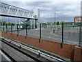
2
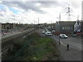
Looking east from Star Lane DLR station
The road approaching the camera, with the car stopped at traffic lights, is Star Lane, from which the Docklands Light Railway station takes its name.
Image: © Christopher Hilton
Taken: 8 Apr 2015
0.08 miles
3
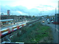
View south from Star Lane DLR station
In the distance, a Docklands Light Railway train heads south to Canning Town after calling at Star Lane; to the right of it the tracks of the Jubilee Line.
Image: © Christopher Hilton
Taken: 4 Feb 2014
0.09 miles
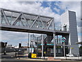
4
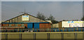
Building products firm, Canning Town
Seen from the DLR.
Image: © Derek Harper
Taken: 17 Apr 2019
0.09 miles
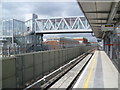
5
View from Star Lane DLR station
The Docklands Light Railway from Canning Town to Stratford International opened in August 2011 on the route of the old North London Line. This closed between Stratford and Canning Town and on to North Woolwich in December 2006. The Jubilee Line runs parallel to the DLR here but does not stop at Star Lane. The view from the footbridge can be seen at http://www.geograph.org.uk/photo/3454714
Image: © Marathon
Taken: 8 May 2013
0.09 miles
6
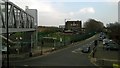
Entrance to Star Lane DLR Station
These stairs and lift are on the junction of Star Lane Manor Road.
The footbridge leads over Manor Road towards the platforms.
Image: © David Anstiss
Taken: 26 Aug 2012
0.09 miles
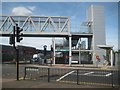
7
Star Lane DLR station
The Docklands Light Railway from Canning Town to Stratford International opened in August 2011 on the route of the old North London Line. This closed between Stratford and Canning Town and on to North Woolwich in December 2006. The Jubilee Line runs parallel to the DLR here to the left but does not stop at Star Lane.
Image: © Marathon
Taken: 8 May 2013
0.09 miles
8
Docklands Light Railway: Star Lane station (eastern entrance)
Star Lane DLR station was opened in 2011. This is the eastern entrance at the junction of Star Lane with the A1011 Manor Road.
Image: © Nigel Cox
Taken: 29 Aug 2019
0.09 miles
9
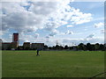
Star Lane Park
As seen from Star Lane, looking across the park towards Canning town.
Image: © David Anstiss
Taken: 26 Aug 2012
0.10 miles
10
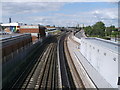
Railway Lines to West Ham
As seen from the footbridge of Star Lane DLR Station.
On the left is the Jubilee Line (tube-train) tracks towards West Ham and Stratford. On the right are the DLR (Docklands light railway) tracks to West Ham and onwards to Stratford.
Image: © David Anstiss
Taken: 26 Aug 2012
0.10 miles