IMAGES TAKEN NEAR TO
Castlemain Street, LONDON, E1 5DA
Introduction
This page details the photographs taken nearby to Castlemain Street, E1 5DA by members of the Geograph project.
The Geograph project started in 2005 with the aim of publishing, organising and preserving representative images for every square kilometre of Great Britain, Ireland and the Isle of Man.

There are currently over 7.5m images from over14,400 individuals and you can help contribute to the project by visiting https://www.geograph.org.uk
Image Map
Images are licensed for reuse under creativecommons.org/licenses/by-sa/2.0
Notes
- Clicking on the map will re-center to the selected point.
- The higher the marker number, the further away the image location is from the centre of the postcode.
Image Listing (350 Images Found)
Images are licensed for reuse under creativecommons.org/licenses/by-sa/2.0
Image
Details
Distance
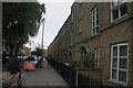
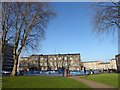
1

View of the houses on Castlemain Street from Vallance Garden
Looking north-northeast.
Image: © Robert Lamb
Taken: 24 Mar 2012
0.02 miles
2
View of houses on Castlemain Street
Looking north-northwest.
Image: © Robert Lamb
Taken: 13 Sep 2015
0.02 miles
3
View of houses on Castlemain Street from Lomas Street
Looking east.
Image: © Robert Lamb
Taken: 4 May 2014
0.02 miles
4
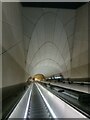
Escalators from Elizabeth Line station, Whitechapel
Image: © Christopher Hilton
Taken: 17 Nov 2022
0.03 miles
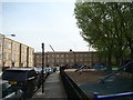
5
Whitechapel: Vallance Gardens
The square, on the east side of Vallance Road, contains some mature London plane trees. The houses in Lomas Street are beyond.
Image: © Nigel Cox
Taken: 1 May 2008
0.03 miles
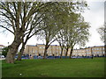
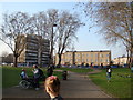
6
Vallance Gardens, Whitechapel
Henrietta Barnett and her husband, Samuel, moved to Whitechapel in 1872 when Samuel became the vicar of St Jude's Church. Henrietta sought to provide parks for children living in cramped Whitechapel tenements, hoping to remove them from the area's overcrowded streets where crime and violence were rife. She transformed a disused Quaker's Burial Ground, established in 1687, into Baker's Row Park for the children. The new park was opened in 1880.
In 1896, Baker's Row was renamed Vallance Road in honour of Mr W. Vallance, the Clerk to the Metropolitan Board of Guardians. The park then became Vallance Road Recreation Ground. A very full history of Vallance Gardens and its social background can be seen at https://surveyoflondon.org/map/feature/1467/detail/
Image: © Marathon
Taken: 26 Jan 2018
0.04 miles
7
View of the houses on Lomas Street and a towerblock on Vallance Road
Looking north-northwest.
Image: © Robert Lamb
Taken: 24 Mar 2012
0.04 miles
8
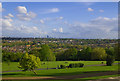
View over North London and beyond from Alexandra Palace
Image: © Jim Osley
Taken: 26 Apr 2014
0.04 miles
9
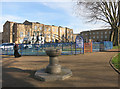
Drinking Fountain in Vallance Gardens
Image: © Des Blenkinsopp
Taken: 11 Feb 2016
0.05 miles
10
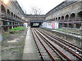
Whitechapel (East London Line) railway station
Opened in 1876 by the East London Railway on the line from New Cross to Shadwell, this was part of the London Underground until 2007.
View north towards Shadwell, but by 2007 this was the end of the line. A week later the line was closed completely for three years. When it was reopened, it was part of the London Overground, now extended north to Dalston Junction (and southwards towards Clapham Junction).
Image: © Nigel Thompson
Taken: 15 Dec 2007
0.05 miles