IMAGES TAKEN NEAR TO
Buxton Street, LONDON, E1 5AS
Introduction
This page details the photographs taken nearby to Buxton Street, E1 5AS by members of the Geograph project.
The Geograph project started in 2005 with the aim of publishing, organising and preserving representative images for every square kilometre of Great Britain, Ireland and the Isle of Man.

There are currently over 7.5m images from over14,400 individuals and you can help contribute to the project by visiting https://www.geograph.org.uk
Image Map
Images are licensed for reuse under creativecommons.org/licenses/by-sa/2.0
Notes
- Clicking on the map will re-center to the selected point.
- The higher the marker number, the further away the image location is from the centre of the postcode.
Image Listing (447 Images Found)
Images are licensed for reuse under creativecommons.org/licenses/by-sa/2.0
Image
Details
Distance
1
Houses on Underwood Road, E1
On the right, at the junction with Vallance Road, is the former pub and hostel shown in Image
Image: © Derek Harper
Taken: 1 Feb 2011
0.03 miles
2
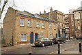
Former pub and hostel, Vallance Road E1
The plaque on the right records the residence here of Quaker Mary Hughes (1860-1941), daughter of novelist (Tom Brown's Schooldays) Thomas Hughes. She acquired this pub, the Earl Grey, in 1926, turned it into a hostel for the homeless and renamed it the Dew Drop Inn. A record of her remarkable life is at http://www.happywarrior.org/genealogy/hughes.htm .
On the left is Underwood Road.
Image: © Derek Harper
Taken: 1 Feb 2011
0.04 miles
3
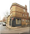
Two Shops Remain
This area would have been streets of terraces at one time. WW2 bombing and subsequent redevelopment have done away with whole blocks, but somehow these two shops on the corner have held on.
Image: © Des Blenkinsopp
Taken: 11 Feb 2016
0.05 miles
4
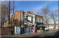
Keen Students School
The Keen Students School is to be found in Vallance Road. See, though, a close up of one of the notices in the window - http://www.geograph.org.uk/photo/3811932
Image: © Marathon
Taken: 8 Jan 2014
0.05 miles
5
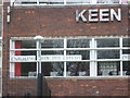
Keen Students School
Keen Students School is to be found in Vallance Road. I am sure though that the spelling is 'enrolling' so I would be a little worried about enroling here for study.
Image: © Marathon
Taken: 8 Jan 2014
0.06 miles
8
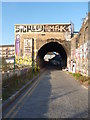
Bethnal Green, Hemming Street
Off Selby Street; most properties in the street are owned by taxi dealers and repairers KPM UK Taxis.
Image: © Mike Faherty
Taken: 15 Sep 2012
0.07 miles
9
Spitalfields City Farm
In 1979, local people turned an area of derelict ex railway land at the eastern end of Weaver Street in Spitalfields into allotments. As time went by, the land was also used to keep poultry and ducks. The number and variety of animals grew, as did the range of activities carried out on the site. This eventually became Spitalfields City Farm. Since then the farm lost some land along its northern side when the East London Line, which was previously in a tunnel, was upgraded to become part of London Overground and was put in a cutting through part of the farm's land. As compensation the farm took some land from Allen Gardens (a rather nondescript park) to the west.
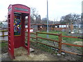
As well as a variety of animals including sheep, pigs, goats, cattle and ferrets the farm runs a variety of activities including a Young Farmers Club and Community Food Growing. See http://www.spitalfieldscityfarm.org/ for more information about the farm. The entrance is in Buxton Street.
This photograph shows an old red telephone box adorned with a number of awards won at the Essex Young Farmers’ Country Show.
Image: © Marathon
Taken: 8 Jan 2014
0.08 miles
10
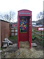
Awards at Spitalfields City Farm
In 1979, local people turned an area of derelict ex railway land at the eastern end of Weaver Street in Spitalfields into allotments. As time went by, the land was also used to keep poultry and ducks. The number and variety of animals grew, as did the range of activities carried out on the site. This eventually became Spitalfields City Farm. Since then the farm lost some land along its northern side when the East London Line, which was previously in a tunnel, was upgraded to become part of London Overground and was put in a cutting through part of the farm's land. As compensation the farm took some land from Allen Gardens (a rather nondescript park) to the west.
As well as a variety of animals including sheep, pigs, goats, cattle and ferrets the farm runs a variety of activities including a Young Farmers Club and Community Food Growing. See http://www.spitalfieldscityfarm.org/ for more information about the farm. The entrance is in Buxton Street.
This photograph shows an old red telephone box adorned with a number of awards won at the Essex Young Farmers’ Country Show.
Image: © Marathon
Taken: 8 Jan 2014
0.08 miles