IMAGES TAKEN NEAR TO
Millstone Close, LONDON, E15 1PD
Introduction
This page details the photographs taken nearby to Millstone Close, E15 1PD by members of the Geograph project.
The Geograph project started in 2005 with the aim of publishing, organising and preserving representative images for every square kilometre of Great Britain, Ireland and the Isle of Man.

There are currently over 7.5m images from over14,400 individuals and you can help contribute to the project by visiting https://www.geograph.org.uk
Image Map
Images are licensed for reuse under creativecommons.org/licenses/by-sa/2.0
Notes
- Clicking on the map will re-center to the selected point.
- The higher the marker number, the further away the image location is from the centre of the postcode.
Image Listing (178 Images Found)
Images are licensed for reuse under creativecommons.org/licenses/by-sa/2.0
Image
Details
Distance
5
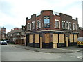
The Windmill Inn public house, Stratford, London E15
Image: © Stacey Harris
Taken: 22 Mar 2010
0.05 miles
6
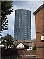
Inspired architect's ultimate phallic symbol (2)
Image: © Mike Quinn
Taken: 30 Jul 2008
0.06 miles
7
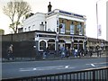
Stratford: Cart & Horses public house
The pub is at 1 Maryland Point.
A glance at the 1881 Census shows the following occupants:
Francis KING, Head of the household, unmarried, aged 26, born West Ham, Essex, occupation Licensed Victualler
Abigail KING, visitor, widowed, aged 75, born St George In the East, Middlesex (his grandmother?)
Abigail KING, his sister, unmarried, aged 27, born West Ham, Essex
Ellen SMITH, unmarried, aged 20, born West Ham, Essex, occupation Barmaid
Image: © Nigel Cox
Taken: 1 May 2008
0.06 miles
8
Inspired architect's ultimate phallic symbol
Something for all the visitors to the Olympics in 2012 to admire.
Image: © Mike Quinn
Taken: 30 Jul 2008
0.06 miles
9
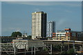
View of Holden Point, Waddington Street and a new unknown block of flats from the footbridge over the station
I don't know what the blue towerblock in the background is called as it doesn't appear in the 2012 Streetview: https://www.google.co.uk/maps/51.546708,0.002346,3a,75y,90.69h,89.36t/data=!3m4!1e1!3m2!1srUqUJsTxLDrxTmnw26bClQ!2e0, but the much older brown towerblock in the foreground is Holden Point on Waddington Street. Looking north-northeast
Image: © Robert Lamb
Taken: 22 Jun 2014
0.06 miles
10
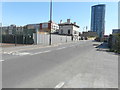
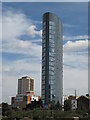
The Railway Tavern, 131, Angel Lane
Planning permission has been granted by Newham Council under application number
16/02650/FUL for the “redevelopment of the site to provide a 298 room hotel ranging in height from 3 to 8 storeys (incorporating a semi enclosed roof terrace) together with the retention (in part) of the existing Railway Tavern Hotel Building with continued drinking establishment, as well as associated car and cycle parking, landscaping and servicing”.
The 19 storey Stratford Eye Tower, which was built 2007-8, dominates the view.
Image: © John Baker
Taken: 5 Apr 2018
0.06 miles