IMAGES TAKEN NEAR TO
Westfield Way, LONDON, E1 4PU
Introduction
This page details the photographs taken nearby to Westfield Way, E1 4PU by members of the Geograph project.
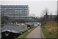
The Geograph project started in 2005 with the aim of publishing, organising and preserving representative images for every square kilometre of Great Britain, Ireland and the Isle of Man.

There are currently over 7.5m images from over14,400 individuals and you can help contribute to the project by visiting https://www.geograph.org.uk
Image Map
Images are licensed for reuse under creativecommons.org/licenses/by-sa/2.0
Notes
- Clicking on the map will re-center to the selected point.
- The higher the marker number, the further away the image location is from the centre of the postcode.
Image Listing (270 Images Found)
Images are licensed for reuse under creativecommons.org/licenses/by-sa/2.0
Image
Details
Distance
1
Car park and railway arches, viewed from the Regent's Canal path
Looking south-southwest.
Image: © Robert Lamb
Taken: 18 Nov 2010
0.01 miles
2
Railway viaduct behind the Queen Mary University Student Residences
I thought I'd just pass the time away whilst I had a spare moment after my lunch break taking a walk around the campus of Queen Mary and taking some "behind-the-scenes" photos. If you walk all the way up the Regents Canal path adjacent to the student residences at Queen Mary to the GER bridge and look left, you get a view of these brick arches carrying the railway as well as a small green, leading to the bins for the nearby halls of residence and a small car park beyond. This is actually as far as you can go into the top-left hand corner of this square (on this side of the railway, anyway). Not the most exciting of views, but an interesting one all the same. View taken looking north-northeast towards Globe Town on the other side of the railway.
Image: © Robert Lamb
Taken: 26 Oct 2009
0.01 miles
3
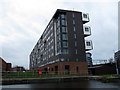
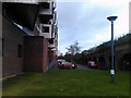
Pooley House
An apartment block with unusual enclosed balconies, perhaps to keep out the noise from the busy railway line only 30m away.
Image: © Stephen Craven
Taken: 11 Jan 2015
0.02 miles
4
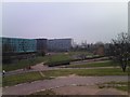
View of Globe Town from the mound in Mile End Park
Looking northwest. A Liverpool Street-Shenfield train can be seen crossing the bridge over the Regent's Canal in the middle distance, whilst Sir Christopher France House (turquoise building, one of Queen Mary University of London's student residence blocks) can be seen to the left.
Image: © Robert Lamb
Taken: 2 Mar 2012
0.03 miles
5
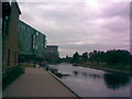
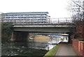
View looking north-northwest along Regent's Canal from Queen Mary University
I've just started my first year of studying at Queen Mary University as an undergraduate, so as a little celebration I thought I'd upload some pictures of Regent's Canal, which flows behind the halls of residence just to the right of the main entrance from Mile End Road. This is the view looking north-northwest along the canal towards Hackney. The Great Eastern Railway between Stratford and Liverpool Street crosses the canal on a small bridge in the background just behind the turquoise residences building.
Image: © Robert Lamb
Taken: 28 Sep 2009
0.03 miles
6
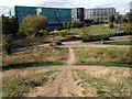
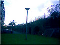
Mile End Park by the Regent's Canal
View northwest from the hillock at the southern end of what is now Mile End Park. In past times there was a reservoir here, next, public pleasure gardens attached to the New Globe Tavern, then the land was used for housing before its resurrection as a public open space. The hill provides excellent views of the surrounding area. A circular access path is crossed by this more direct route.
Image: © Natasha Ceridwen de Chroustchoff
Taken: 4 Oct 2009
0.03 miles
7
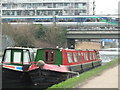
Narrow boats on the Regents Canal, Mile End
Image: © Ruth Sharville
Taken: 21 Feb 2011
0.04 miles
8
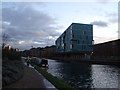
View of Sir Christopher France House from the Regent's Canal
Looking south-southwest.
Image: © Robert Lamb
Taken: 16 Dec 2011
0.04 miles