IMAGES TAKEN NEAR TO
Marsh Wall, LONDON, E14 9TP
Introduction
This page details the photographs taken nearby to Marsh Wall, E14 9TP by members of the Geograph project.
The Geograph project started in 2005 with the aim of publishing, organising and preserving representative images for every square kilometre of Great Britain, Ireland and the Isle of Man.

There are currently over 7.5m images from over14,400 individuals and you can help contribute to the project by visiting https://www.geograph.org.uk
Image Map
Images are licensed for reuse under creativecommons.org/licenses/by-sa/2.0
Notes
- Clicking on the map will re-center to the selected point.
- The higher the marker number, the further away the image location is from the centre of the postcode.
Image Listing (586 Images Found)
Images are licensed for reuse under creativecommons.org/licenses/by-sa/2.0
Image
Details
Distance
2
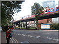
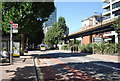
Marsh Wall E14
A road through Docklands across the centre of the Isle of Dogs, linking Westferry Circus to Preston's Road on the east side.
Image: © Rod Allday
Taken: 16 Oct 2010
0.02 miles
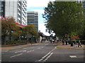
7

View of the new Novotel hotel from Admirals Way
Looking north-northwest.
Image: © Robert Lamb
Taken: 31 Jul 2016
0.03 miles
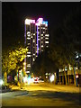
9
View of blocks and flats behind 56 Marsh Wall from Marsh Wall
Looking south-southwest.
Image: © Robert Lamb
Taken: 13 Aug 2017
0.03 miles
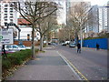
10

View of Clipper House on the corner of Byng Street and Mastmaker Road from Millwall Inner Dock
Looking north-northwest.
Image: © Robert Lamb
Taken: 31 Jul 2016
0.03 miles