IMAGES TAKEN NEAR TO
Harbord Square, LONDON, E14 9NJ
Introduction
This page details the photographs taken nearby to Harbord Square, E14 9NJ by members of the Geograph project.
The Geograph project started in 2005 with the aim of publishing, organising and preserving representative images for every square kilometre of Great Britain, Ireland and the Isle of Man.

There are currently over 7.5m images from over14,400 individuals and you can help contribute to the project by visiting https://www.geograph.org.uk
Image Map
Images are licensed for reuse under creativecommons.org/licenses/by-sa/2.0
Notes
- Clicking on the map will re-center to the selected point.
- The higher the marker number, the further away the image location is from the centre of the postcode.
Image Listing (376 Images Found)
Images are licensed for reuse under creativecommons.org/licenses/by-sa/2.0
Image
Details
Distance
1
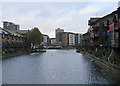
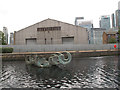
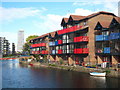
Flats by the water
This is the former West India Graving Dock (1878-1979), off Blackwall Basin. The caisson was removed in 1985, flooding the dry dock, and a concrete bridge was built in 1988. This picture was taken from the Lovegrove Walk bridge.
Image: © John Sutton
Taken: 2 Nov 2019
0.06 miles
2
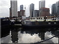
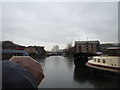
Blackwall Basin
Blackwall Basin was opened in 1802. It was the first impounded, or non-tidal, dock entrance basin ever built. In effect it served as an enormous entrance lock to the West India Docks. A number of ships could be locked into the basin around high tide, remain afloat there when the tide receded, and then lock into the docks when convenient, without affecting the water level in the docks.
The docks were closed in 1980 as the Canary Wharf development began. As can be seen here, they are still used extensively for leisure. See also https://www.geograph.org.uk/photo/7399156
Image: © Marathon
Taken: 1 Feb 2023
0.06 miles
3
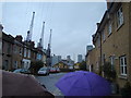
View of the South Quay area and dock cranes from Coldharbour
Looking north-northwest.
Image: © Robert Lamb
Taken: 24 Nov 2012
0.06 miles
4
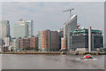
Canary Wharf as seen from The River Thames
As seen from the "Waverley" paddle steamer.
Image: © Christine Matthews
Taken: 2 Oct 2014
0.06 miles
5
Sculpture in water
A metal sculpture emerging from an arm of the Blackwall Basin.
Image: © Stephen Craven
Taken: 15 Jun 2014
0.07 miles
6
View of Galleons View from Blackwall Dock
Looking south-southeast.
Image: © Robert Lamb
Taken: 24 Nov 2012
0.07 miles
7
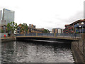
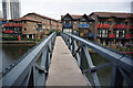
Lovegrove Walk bridge
A fixed bridge carrying a local road over an arm of the Blackwall Basin.
Image: © Stephen Craven
Taken: 15 Jun 2014
0.07 miles
8
Housing, Lawrence Drive
View from the Lovegrove Path footbridge over the mouth of Blackwall Basin.
Image: © Jim Osley
Taken: 24 Feb 2016
0.07 miles
9
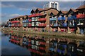
Houses on Blackwall Basin
Low rise waterside housing on the eastern edge of the Canary Wharf development.
Image: © Rod Allday
Taken: 16 Oct 2010
0.07 miles
10
Turf Zone "LoveDock"
Footbridge off Lovegrove Walk, Isle of Dogs.
Image: © Ian S
Taken: 25 Dec 2022
0.07 miles