IMAGES TAKEN NEAR TO
Goodhart Place, LONDON, E14 8EG
Introduction
This page details the photographs taken nearby to Goodhart Place, E14 8EG by members of the Geograph project.
The Geograph project started in 2005 with the aim of publishing, organising and preserving representative images for every square kilometre of Great Britain, Ireland and the Isle of Man.

There are currently over 7.5m images from over14,400 individuals and you can help contribute to the project by visiting https://www.geograph.org.uk
Image Map (Loading...)


Getting Data...Please wait
Leaflet Map data © OpenStreetMap
Images are licensed for reuse under creativecommons.org/licenses/by-sa/2.0
Notes
- Clicking on the map will re-center to the selected point.
- The higher the marker number, the further away the image location is from the centre of the postcode.
Image Listing (480 Images Found)
Images are licensed for reuse under creativecommons.org/licenses/by-sa/2.0
Image
Details
Distance
1
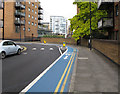
Cycle Superhighway in Horseferry Road
The CS3 cycle superhighway runs from Barking to Tower Gateway. It is shown by the blue surface.
Image: © David Hawgood
Taken: 10 Oct 2015
0.01 miles
2
Marina office, Limehouse Basin
Boaters who arrive at Limehouse Basin, whether to moor overnight or just passing through, will be pleased to find this modern office, where a very pleasant young lady will advise you, or sell you such useful items as lock windlasses, maps and guides.
Image: © Dr Neil Clifton
Taken: 3 Sep 2008
0.02 miles
3
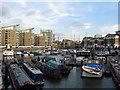
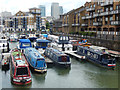
Limehouse Basin
Formerly this marina was called Regent's Canal Dock. All sorts of craft are moored here, ranging from narrow-beam canal cruisers to ocean-going yachts. There is a small modern marina office where very helpful and knowledgeable staff are available to advise boaters, and charts, equipment etc. may be purchased.
Image: © Dr Neil Clifton
Taken: 19 Nov 2008
0.02 miles
4
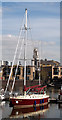
Limehouse Basin
This was originally Regent's Canal Dock - the point where the Regent's Canal entered the Thames. Regent's Canal Dock closed to shipping in 1969, and by 2001 it had been transformed into Limehouse Basin. The tower in the distance in the middle of the photograph belongs to St Anne's Church, Limehouse.
Image: © Marathon
Taken: 27 Jul 2011
0.02 miles
5
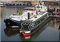
Limehouse Basin (4)
The private yacht Ocean Lady in Limehouse Basin.
Image: © The Carlisle Kid
Taken: 10 Apr 2014
0.03 miles
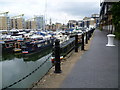
6
Limehouse Basin
Limehouse Basin forms the end of the Regent's Canal and the Lee Navigation. It was formerly known as Regent's Canal Dock, handling shipping arriving via the Thames, but closed in 1969 as part of the general decline of the London docks. In 2001 it became a marina available to both canal and river craft.
Image: © Stephen McKay
Taken: 30 Jul 2015
0.03 miles
7
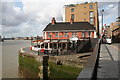
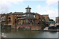
The 'Narrow', Limehouse
Thames-side public house at the west end of the swing bridge on Narrow Street which gives access to and from Limehouse Basin, via Limehouse Lock.
Image: © Dr Neil Clifton
Taken: 3 Sep 2008
0.03 miles
8
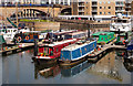
Limehouse Basin (5)
A collection of canal narrowboats, mostly converted to private use, in Limehouse Basin.
Image: © The Carlisle Kid
Taken: 10 Apr 2014
0.04 miles
9
Limehouse Basin (6)
A converted narrowboat and a private canal cruiser in Limehouse Basin.
Image: © The Carlisle Kid
Taken: 10 Apr 2014
0.04 miles
10
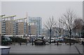
Limehouse Basin
A basin at the end of the Regents Canal.
Image: © N Chadwick
Taken: 12 Feb 2012
0.04 miles