IMAGES TAKEN NEAR TO
Galsworthy Avenue, LONDON, E14 7RA
Introduction
This page details the photographs taken nearby to Galsworthy Avenue, E14 7RA by members of the Geograph project.
The Geograph project started in 2005 with the aim of publishing, organising and preserving representative images for every square kilometre of Great Britain, Ireland and the Isle of Man.

There are currently over 7.5m images from over14,400 individuals and you can help contribute to the project by visiting https://www.geograph.org.uk
Image Map (Loading...)


Getting Data...Please wait
Leaflet Map data © OpenStreetMap
Images are licensed for reuse under creativecommons.org/licenses/by-sa/2.0
Notes
- Clicking on the map will re-center to the selected point.
- The higher the marker number, the further away the image location is from the centre of the postcode.
Image Listing (217 Images Found)
Images are licensed for reuse under creativecommons.org/licenses/by-sa/2.0
Image
Details
Distance
2
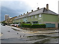
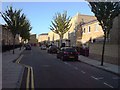
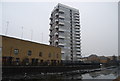
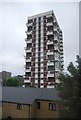
Stepney: Limehouse Fields Estate, E14
Stepney suffered greatly during the Blitz, and there was a desperate need in the immediate post-war years not only to re-house people whose homes had been destroyed but also to cater for demobilized service personnel returning home to civilian life. The Limehouse Fields Estate was one of the main developments to solve these problems. Three different types of housing can be seen here. The nearest, and somewhat unusually green, houses are Donoghue Cottages, built in 1949. Further down the road, which is Galsworthy Avenue, are some more recent (1990s?) houses, while in the distance is a towerblock, probably dating from the 1960s.
Image: © Nigel Cox
Taken: 1 May 2008
0.04 miles
3
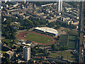
Mile End Athletics Stadium from the air
Prominent on the approach to London City airport from the west.
Image: © Thomas Nugent
Taken: 26 Aug 2019
0.06 miles
7
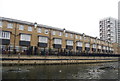
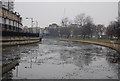
Regent's Canal
A section close to the Thames end of the canal, just north of Limehouse Basin.
Image: © John Allan
Taken: 18 Aug 2010
0.08 miles
8
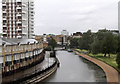
The Regents Canal
Laballed on the map as the Grand Union Canal of which it was an extension. Seen in Limehouse from a Fenchurch Street bound C2C train service.
Image: © Martin Addison
Taken: 12 Jun 2011
0.09 miles
10
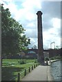
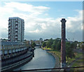
'Chimney' beside Regents Canal
I could see warm air rising from this 'chimney' which is in fact a sewer ventilating column.
Image: © ANDY FISH
Taken: 5 May 2005
0.09 miles