IMAGES TAKEN NEAR TO
Commercial Road, LONDON, E14 7HS
Introduction
This page details the photographs taken nearby to Commercial Road, E14 7HS by members of the Geograph project.
The Geograph project started in 2005 with the aim of publishing, organising and preserving representative images for every square kilometre of Great Britain, Ireland and the Isle of Man.

There are currently over 7.5m images from over14,400 individuals and you can help contribute to the project by visiting https://www.geograph.org.uk
Image Map
Images are licensed for reuse under creativecommons.org/licenses/by-sa/2.0
Notes
- Clicking on the map will re-center to the selected point.
- The higher the marker number, the further away the image location is from the centre of the postcode.
Image Listing (468 Images Found)
Images are licensed for reuse under creativecommons.org/licenses/by-sa/2.0
Image
Details
Distance
1
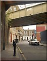
Mill Place, E14
The street in Limehouse, seen from beneath two railway arches, the nearer carrying the DLR. The Georgian houses facing the camera are on Commercial Road.
Image: © Derek Harper
Taken: 1 Feb 2011
0.01 miles
2
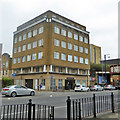
Regents Canal House, Commercial Road, Limehouse
Flats.
Image: © Robin Webster
Taken: 6 Apr 2019
0.01 miles
3
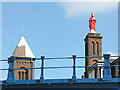
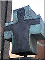
Our Lady Immaculate, Limehouse
The statue on the church is known as the "steering Christ" as it acted as a navigation aid to sailors coming into the docks.
Image: © Stephen Craven
Taken: 2 May 2009
0.01 miles
4
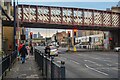
London : Tower Hamlets - Commercial Road A13
Looking along Commercial Road.
Image: © Lewis Clarke
Taken: 22 Feb 2023
0.01 miles
5
Cross, Our Lady of Immaculate Conception, Commercial Road E14
Image: © Robin Sones
Taken: 24 Aug 2010
0.02 miles
6
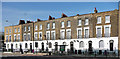
699-711 Commercial Road
An early C19th terrace, like the one a little to the west (Image]) except that the first-floor windows have moulded architraves, a trait which marks the onset of Victorian style, generally heavier and less refined than its Georgian predecessor. Grade II listed.
Image: © Stephen Richards
Taken: 12 Mar 2012
0.02 miles
7
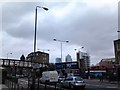
View of Canary Wharf from Commercial Road
Looking south-southeast. The viaduct looks to be another remnant of the London and Blackwall Railway. A DLR train can be seen rounding the curve into Limehouse station in the background.
Image: © Robert Lamb
Taken: 24 Apr 2012
0.02 miles
8
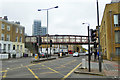
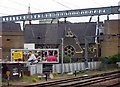
Disused railway bridge over Commercial Road
A grade II listed structure of the 1870s. This carried the Limehouse Curve, this enabled Great Eastern Railway goods trains to run straight through to the docks without reversal west of the existing Limehouse Junction.
Image: © Robin Webster
Taken: 6 Apr 2019
0.02 miles
10
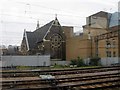
Church of the English Martyrs from DRL
Image: © John Salmon
Taken: 16 May 2008
0.03 miles