IMAGES TAKEN NEAR TO
Thomas Road, LONDON, E14 7FS
Introduction
This page details the photographs taken nearby to Thomas Road, E14 7FS by members of the Geograph project.
The Geograph project started in 2005 with the aim of publishing, organising and preserving representative images for every square kilometre of Great Britain, Ireland and the Isle of Man.

There are currently over 7.5m images from over14,400 individuals and you can help contribute to the project by visiting https://www.geograph.org.uk
Image Map
Images are licensed for reuse under creativecommons.org/licenses/by-sa/2.0
Notes
- Clicking on the map will re-center to the selected point.
- The higher the marker number, the further away the image location is from the centre of the postcode.
Image Listing (69 Images Found)
Images are licensed for reuse under creativecommons.org/licenses/by-sa/2.0
Image
Details
Distance
1
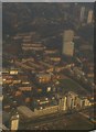
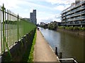
Bow Common, from the air
In the foreground, Limehouse Cut runs along the front of a housing estate; in the background, just visible, the curving railway lines joining the Fenchurch Street lines to those out of Liverpool Street, and in the top left the corner of Tower Hamlets cemetery.
Taken from the approach to London City Airport, photographer's position conjectural.
Image: © Christopher Hilton
Taken: 13 Dec 2012
0.02 miles
2
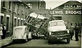
Thomas Road Bow Common East London. 1956
He took the corner just a bit too fast.
Image: © Derek Voller
Taken: 3 May 1956
0.03 miles
3
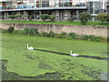
Two swans aswimming, Limehouse Cut
The swans are swimming through a film of duckweed, which leaves an open channel briefly then closes behind them. Photo from towpath by Cotall Street.
Image: © David Hawgood
Taken: 10 Oct 2015
0.04 miles
4
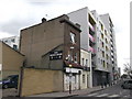
The Bridge House, Bow
Closed public house on Bow Common Lane, leading towards Limehouse Cut (canal).
Beside a large block of modern apartments beside the canal.
Image: © David Anstiss
Taken: 15 Feb 2012
0.04 miles
5
Bow, Limehouse Cut
Canal linking River Lea with Limehouse Basin on the Thames. http://www.londoncanals.co.uk/leenav/lh01.html
Image: © Mike Faherty
Taken: 26 Aug 2012
0.04 miles
6
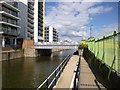
Arch entry to Limehouse Cut towpath
The metal arch with the words "Limehouse Cut" curved around inside the top of the arch gives access from Cotall Street to a ramp down to the canal towpath.
Image: © David Hawgood
Taken: 10 Oct 2015
0.05 miles
7
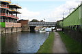
Bow Common Lane bridge over Limehouse Cut
Limehouse Cut is hardly one of England's more popular canals, so it was fortunate that a small cruiser was passing under this bridge just as I took the photograph. This is looking northeast. Bow Common Lane is the name of the road to the left of the bridge, while at the right it changes its name to Upper North Street. It is not a classified road, but does carry a bus route - the 309 from Bethnal Green to Canning Town. It is one of those roads beloved of cabbies and white-van men who know 'all the dodges'.
Image: © Dr Neil Clifton
Taken: 3 Sep 2008
0.05 miles
8
Bow, road bridge
Carrying Bow Common Road over Limehouse Cut.
Image: © Mike Faherty
Taken: 26 Aug 2012
0.05 miles
9
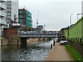
Bow Common Lane Bridge, Limehouse Cut
The bridges over the cut are named but not visibly numbered.
Image: © Robin Webster
Taken: 11 Dec 2010
0.05 miles
10
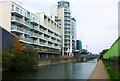
Limehouse Cut
Looking north-east towards Bow Common Lane bridge. The development on the left is Silver Wharf the construction of which can be seen in Image
Image: © David Kemp
Taken: 1 Nov 2010
0.06 miles