IMAGES TAKEN NEAR TO
Venue Street, LONDON, E14 6QA
Introduction
This page details the photographs taken nearby to Venue Street, E14 6QA by members of the Geograph project.
The Geograph project started in 2005 with the aim of publishing, organising and preserving representative images for every square kilometre of Great Britain, Ireland and the Isle of Man.

There are currently over 7.5m images from over14,400 individuals and you can help contribute to the project by visiting https://www.geograph.org.uk
Image Map (Loading...)


Getting Data...Please wait
Leaflet Map data © OpenStreetMap
Images are licensed for reuse under creativecommons.org/licenses/by-sa/2.0
Notes
- Clicking on the map will re-center to the selected point.
- The higher the marker number, the further away the image location is from the centre of the postcode.
Image Listing (105 Images Found)
Images are licensed for reuse under creativecommons.org/licenses/by-sa/2.0
Image
Details
Distance
2
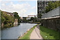
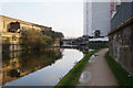
View along Limehouse Cut
Looking northeast. In the distance is the bridge carrying the Blackwall Tunnel Approach Road.
Image: © Dr Neil Clifton
Taken: 3 Sep 2008
0.07 miles
3
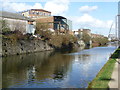
The Limehouse Cut
The Limehouse Cut was built in 1770 to connect the River Lea to the Thames and so shorten the journey for vessels travelling from the River Lea to the Pool of London. It did this by cutting out several loops of the lower Lea and the Thames. In the 19th century it was so polluted that "no bargee who fell in had any chance of surviving his ducking in the filthy water".
The Limehouse Cut was closed to pedestrians for many years but the towpath has been opened up in the last few years so that it is now possible to walk from Limehouse Basin to Three Mills via the new bridge under the Blackwall Tunnel approach road.
Image: © Marathon
Taken: 26 Feb 2014
0.08 miles
4
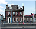
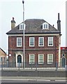
Bromley Hall, Blackwall Tunnel Approach Road
A surprising find, now incongruously looking out over a busy dual carriageway. From the exterior it looks c1700, but recent investigation has unearthed evidence which suggests that this building was once part of a Tudor manor house. Grade II* listed.
Behind and to the right can be seen the tops of offices, complete with portholes, fashioned out of red containers.
Image: © Stephen Richards
Taken: 4 Jun 2011
0.08 miles
5

Limehouse Cut
The canal (see also http://www.geograph.org.uk/search.php?i=18757043) runs across the southeast corner of the square. On the right is the four-storey building shown in Image, which is mapped as the Poplar Centre of Hackney College, but since 1994 it has been the home of the Limehouse Arts Foundation http://www.limehouseartsfoundation.org/pages/about.html .
Image: © Derek Harper
Taken: 12 Jan 2011
0.09 miles
7
Bromley Hall, Gillender Street, London E14
Grade II* listed building, described at this http://list.historicengland.org.uk/resultsingle.aspx?uid=1357791. See also this http://www.british-history.ac.uk/survey-london/vol1/pp17-18 ; and, this http://acme.org.uk/downloads/henrys%20east%20ender%20010206.pdf.
Image: © Jim Osley
Taken: 24 Apr 2015
0.09 miles


10
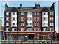
Former fire station, Gillender Street
A fine example of the former London County Council's Arts-and-Craft style fire stations, dating from 1909-11. It definitely has that air of domesticity for which the style was always striving - if you ignore the ground floor, you'd think this is a block of flats. The architect may have been W.E. Brooks. Grade II listed.
It is now artists' studios.
Image: © Stephen Richards
Taken: 4 Jun 2011
0.10 miles