IMAGES TAKEN NEAR TO
Brabazon Street, LONDON, E14 6LA
Introduction
This page details the photographs taken nearby to Brabazon Street, E14 6LA by members of the Geograph project.
The Geograph project started in 2005 with the aim of publishing, organising and preserving representative images for every square kilometre of Great Britain, Ireland and the Isle of Man.

There are currently over 7.5m images from over14,400 individuals and you can help contribute to the project by visiting https://www.geograph.org.uk
Image Map
Images are licensed for reuse under creativecommons.org/licenses/by-sa/2.0
Notes
- Clicking on the map will re-center to the selected point.
- The higher the marker number, the further away the image location is from the centre of the postcode.
Image Listing (90 Images Found)
Images are licensed for reuse under creativecommons.org/licenses/by-sa/2.0
Image
Details
Distance
1
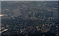
The Isle of Dogs from the air
Looking south on a gloomy day, the great loop and the buildings at Canary Wharf are prominent. The O2 Arena can be seen on the left, as can the River Lea or Lee.
Image: © Thomas Nugent
Taken: 31 Jul 2015
0.01 miles
2
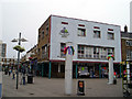
Chrisp Street Market, Poplar
The Chrisp Street retail centre is on the Lansbury Estate, which was part of the 1951 Festival of Britain and was the first specially designed pedestrianised shopping centre in the UK.
Image: © David Bradbury
Taken: 13 Aug 2005
0.01 miles
3
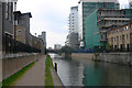
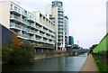
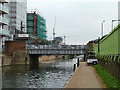
Limehouse Cut
Looking south-west to the bridge carrying Bow Common Lane across the canal.
Image: © David Kemp
Taken: 1 Nov 2010
0.08 miles
4
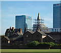
Church of St Saviour, Poplar
Grade II listed church dating from 1873-4 to a design by Frederick J and Horace Francis. Declared redundant in 1984, listed in 1989, but severely damaged by fire in May 2007 and is currently propped by scaffolding. Pre-fire description at this https://historicengland.org.uk/listing/the-list/list-entry/1242275.
Image: © Jim Osley
Taken: 10 May 2017
0.09 miles
5
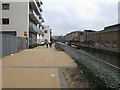
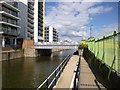
Walkway by the Limehouse Cut, Bow Common
The walkway gives access from Bow Common Lane to Hawgood Street, along the front of new apartment blocks.
Image: © David Hawgood
Taken: 10 Oct 2015
0.09 miles
6
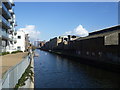
The Limehouse Cut from Bow Common Lane
The Limehouse Cut was built in 1770 to connect the River Lea to the Thames and so shorten the journey for vessels travelling from the River Lea to the Pool of London. It did this by cutting out several loops of the lower Lea and the Thames. In the 19th century it was so polluted that "no bargee who fell in had any chance of surviving his ducking in the filthy water".
The Limehouse Cut was closed to pedestrians for many years but the towpath has been opened up in the last few years so that it is now possible to walk from Limehouse Basin to Three Mills via the new bridge under the Blackwall Tunnel approach road.
Image: © Marathon
Taken: 26 Feb 2014
0.09 miles
7
Limehouse Cut
Looking north-east towards Bow Common Lane bridge. The development on the left is Silver Wharf the construction of which can be seen in Image
Image: © David Kemp
Taken: 1 Nov 2010
0.10 miles
8
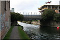
Bow Common Lane bridge over Limehouse Cut
Looking Southwest. See also Image
Image: © Dr Neil Clifton
Taken: 3 Sep 2008
0.10 miles
9
Bow Common Lane Bridge, Limehouse Cut
The bridges over the cut are named but not visibly numbered.
Image: © Robin Webster
Taken: 11 Dec 2010
0.10 miles
10
Bow, road bridge
Carrying Bow Common Road over Limehouse Cut.
Image: © Mike Faherty
Taken: 26 Aug 2012
0.10 miles