IMAGES TAKEN NEAR TO
Vesey Path, LONDON, E14 6BP
Introduction
This page details the photographs taken nearby to Vesey Path, E14 6BP by members of the Geograph project.
The Geograph project started in 2005 with the aim of publishing, organising and preserving representative images for every square kilometre of Great Britain, Ireland and the Isle of Man.

There are currently over 7.5m images from over14,400 individuals and you can help contribute to the project by visiting https://www.geograph.org.uk
Image Map
Images are licensed for reuse under creativecommons.org/licenses/by-sa/2.0
Notes
- Clicking on the map will re-center to the selected point.
- The higher the marker number, the further away the image location is from the centre of the postcode.
Image Listing (240 Images Found)
Images are licensed for reuse under creativecommons.org/licenses/by-sa/2.0
Image
Details
Distance
1
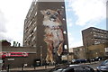
View of a dog mural on the side of a block of flats on Chrisp Street
Looking north-northwest.
Image: © Robert Lamb
Taken: 5 Sep 2020
0.00 miles
3
Chrisp Street Market, E14
Entrance to Chrisp Street Market, off East India Dock Road.
Image: © Malc McDonald
Taken: 17 Apr 2010
0.02 miles
4
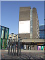
Chrisp Street market fountain
This sculpture, apparently representing a cluster of nails, was installed in 1989 as a fountain. It can be seen at the East India Dock Road entrance to the market and the Lansbury Estate, an early post-war iniative in social housing following the destruction of the area during the Blitz. Could the nails have some connection with the theme of joining or fixing?
Image: © Natasha Ceridwen de Chroustchoff
Taken: 26 Jun 2008
0.03 miles
5
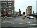
East India Dock Road
Looking west from the top of Newby Place. The slight rise in the street, left, is where the Docklands Light railway passes below, at All Saints (formerly Poplar) Station.
Image: © Natasha Ceridwen de Chroustchoff
Taken: 26 Jun 2008
0.03 miles
6
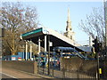
All Saints DLR
Entrance to the Docklands Light Railway station at All Saints, Poplar.
Image: © Malc McDonald
Taken: 17 Apr 2010
0.03 miles
7
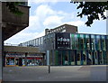
The Idea Store, Poplar
What used to be known as a library! This state-of-the-art version has been designed to provide a community resource here on the Lansbury Estate with all sorts of classes, courses and creative opportunities, as well as a cafe. And books! Read about it here http://arts.guardian.co.uk/reviews/observer/story/0,,1258372,00.html
Image: © Natasha Ceridwen de Chroustchoff
Taken: 26 Jun 2008
0.03 miles
8
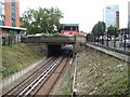
Poplar: Docklands Light Railway
Viewed from the Susannah Street bridge and looking towards the East India Dock Road bridge, the Docklands Light Railway (DLR) here uses the route of the former North London Railway (NLR) between Poplar and Bow. The entrance façade to All Saints DLR station can be seen on the far side of the bridge. All Saints is named after the nearby church and was previously the site of Poplar station on the NLR. Image is visible on the right and the base of Image is visible on the left.
Image: © Nigel Cox
Taken: 19 Aug 2008
0.03 miles
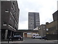
10
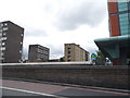
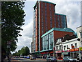
Tower blocks by East India Dock Road, Poplar
Image: © David Howard
Taken: 27 Apr 2014
0.03 miles