IMAGES TAKEN NEAR TO
Manchester Road, LONDON, E14 3NU
Introduction
This page details the photographs taken nearby to Manchester Road, E14 3NU by members of the Geograph project.
The Geograph project started in 2005 with the aim of publishing, organising and preserving representative images for every square kilometre of Great Britain, Ireland and the Isle of Man.

There are currently over 7.5m images from over14,400 individuals and you can help contribute to the project by visiting https://www.geograph.org.uk
Image Map (Loading...)


Getting Data...Please wait
Leaflet Map data © OpenStreetMap
Images are licensed for reuse under creativecommons.org/licenses/by-sa/2.0
Notes
- Clicking on the map will re-center to the selected point.
- The higher the marker number, the further away the image location is from the centre of the postcode.
Image Listing (271 Images Found)
Images are licensed for reuse under creativecommons.org/licenses/by-sa/2.0
Image
Details
Distance
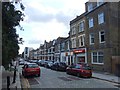
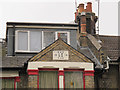
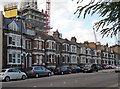
1
Victorian terraced housing in Glen Terrace
Surrounded now by modern development. The cranes are those in Image
Image: © Rod Allday
Taken: 16 Oct 2010
0.00 miles
2
Manchester Road, Isle of Dogs
Terraced houses on the stub of Manchester Road leading to the ship lock.
Image: © Stephen Craven
Taken: 23 May 2015
0.00 miles
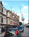
3
Isle of Dogs: 583 - 615 Manchester Road
This is a terrace of Victorian houses that survived World War II bombing, and the wholesale redevelopment of the Isle of Dogs. When they were first built they fronted directly onto Manchester Road which then crossed the lock between the Thames and the West India Docks by a swing bridge. Since then the bridge has been rebuilt further to the east and the main road, now the A1206, veers away from their frontage, as seen in the foreground.
Image: © Nigel Cox
Taken: 6 Sep 2018
0.01 miles
4
1974 datestone on Manchester Road
I guess the date refers to the addition of the dormer window: the terraced houses on this road Image are much older.
Image: © Stephen Craven
Taken: 23 May 2015
0.02 miles
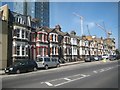
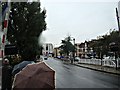
5
Manchester Road
Looking towards the bridge at the eastern end of South Dock.
Image: © DS Pugh
Taken: 2 Aug 2022
0.02 miles
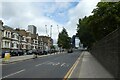
6
View down Preston's Road from The Blue Bridge
Looking south-southwest.
Image: © Robert Lamb
Taken: 24 Nov 2012
0.02 miles
7
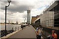
View of a new tower being constructed off Manchester Road from South Dock #2
Looking south-southeast.
Image: © Robert Lamb
Taken: 31 Jul 2016
0.02 miles
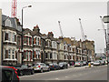
8
583-611 Manchester Road
Of no intrinsic interest, simply the remarkable turn-up of a Victorian terrace a stone's throw from Canary Wharf (growing ever closer as can be seen behind).
Image: © Stephen Richards
Taken: 26 Sep 2015
0.02 miles
9
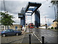
Isle of Dogs: West India Docks drawbridge
Known to all as the blue bridge the drawbridge enables traffic on the A1206 Preston's Road to pass over the channel leading to the South Dock of the West India Docks from the Blackwall Reach of the River Thames. The drawbridge was built between 1967 and 1969 and some indication of its size can be gained by the dwarfing of the double-decker bus beneath it.
Image: © Nigel Cox
Taken: 1 May 2008
0.03 miles