IMAGES TAKEN NEAR TO
East Ferry Road, LONDON, E14 3LB
Introduction
This page details the photographs taken nearby to East Ferry Road, E14 3LB by members of the Geograph project.
The Geograph project started in 2005 with the aim of publishing, organising and preserving representative images for every square kilometre of Great Britain, Ireland and the Isle of Man.

There are currently over 7.5m images from over14,400 individuals and you can help contribute to the project by visiting https://www.geograph.org.uk
Image Map (Loading...)


Getting Data...Please wait
Leaflet Map data © OpenStreetMap
Images are licensed for reuse under creativecommons.org/licenses/by-sa/2.0
Notes
- Clicking on the map will re-center to the selected point.
- The higher the marker number, the further away the image location is from the centre of the postcode.
Image Listing (246 Images Found)
Images are licensed for reuse under creativecommons.org/licenses/by-sa/2.0
Image
Details
Distance
1
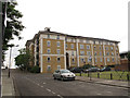
Walkers Lodge, 579 Manchester Road, London, E14 3NT
A block of flats on the corner of Manchester Road and Marsh Wall South Quay.
Image: © Danny P Robinson
Taken: 27 Aug 2009
0.03 miles
2
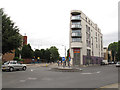
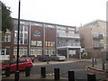
Mini-roundabout on Manchester Road
The wedge-shaped building is in the angle between Manchester Road and East Ferry Road, and on the ground floor includes Amata restaurant and a Tesco express.
Image: © Stephen Craven
Taken: 15 Jun 2014
0.03 miles
3
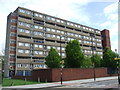
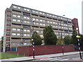
Block of flats, Manchester Road
Block of flats on Manchester Road.
Image: © Malc McDonald
Taken: 3 May 2010
0.04 miles
4
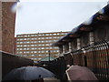
View of the Samuda Estate from the passageway beside the pumping station
Looking west.
Image: © Robert Lamb
Taken: 24 Nov 2012
0.04 miles
5
Island House, Isle of Dogs
Community Centre, part of a housing development on Roserton Street.
Seen from Castilia Square.
Image: © David Anstiss
Taken: 20 Nov 2011
0.06 miles
6
Alice Shepherd House, Manchester Road, E14
Alice Shepherd had been a long standing local councillor in the area.
Image: © Danny P Robinson
Taken: 27 Aug 2009
0.06 miles
7
Galleons View
Another part of the same development as Image
Image: © Stephen Craven
Taken: 15 Jun 2014
0.07 miles
8
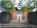
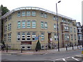
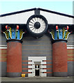
Isle of Dogs Pumping Station front elevation
Designed by John Outram. For details see Image
Image: © Rod Allday
Taken: 16 Oct 2010
0.07 miles
9
Pumping station, Stewart Street
Unmistakably the work of John Outram, 1987-88, who described it as a "temple to summer storms". "The walls represent a blue brick river flowing between tree trunks, and the round hole of the fan which splits the gable is the cave between mountain peaks through which the river issues, falling as blue bricks down the wall ... practically, the brick chamber conceals a subterranean concrete pumping chamber, tank and control room. The columns carry ducts, and the axial fan in the metal-panelled gables prevents build-up of methane." Grade II* listed.
Image: © Stephen Richards
Taken: 26 Sep 2015
0.07 miles
10
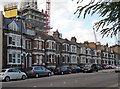
583-611 Manchester Road
Of no intrinsic interest, simply the remarkable turn-up of a Victorian terrace a stone's throw from Canary Wharf (growing ever closer as can be seen behind).
Image: © Stephen Richards
Taken: 26 Sep 2015
0.07 miles