IMAGES TAKEN NEAR TO
Friars Mead, LONDON, E14 3JY
Introduction
This page details the photographs taken nearby to Friars Mead, E14 3JY by members of the Geograph project.
The Geograph project started in 2005 with the aim of publishing, organising and preserving representative images for every square kilometre of Great Britain, Ireland and the Isle of Man.

There are currently over 7.5m images from over14,400 individuals and you can help contribute to the project by visiting https://www.geograph.org.uk
Image Map (Loading...)


Getting Data...Please wait
Leaflet Map data © OpenStreetMap
Images are licensed for reuse under creativecommons.org/licenses/by-sa/2.0
Notes
- Clicking on the map will re-center to the selected point.
- The higher the marker number, the further away the image location is from the centre of the postcode.
Image Listing (163 Images Found)
Images are licensed for reuse under creativecommons.org/licenses/by-sa/2.0
Image
Details
Distance
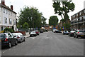
1
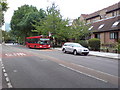
Manchester Road, E14
Near the junction with Friars Mead. A D3 bus is on its way to Bethnal Green.
Image: © Danny P Robinson
Taken: 27 Aug 2009
0.05 miles
2
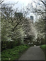
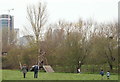
Spring blooms at Mudchute Farm
Looking towards the towerblock on the Isle of Dogs.
Image: © Alison Nugent
Taken: 23 Feb 2020
0.06 miles
3
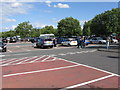
Asda Superstore Car Park - Crossharbour
Image: © Peter Whatley
Taken: 26 May 2009
0.07 miles
4
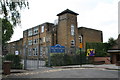
Cubitt Town Junior and Infant Schools
At the east end of Glengall Grove.
Image: © Dr Neil Clifton
Taken: 14 Jun 2012
0.07 miles
5
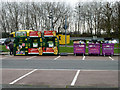
Recycling bins, E14
In the Asda car park.
Image: © Robin Webster
Taken: 5 Mar 2011
0.08 miles
6
Cubitt Town: Glengall Grove
Looking east
Image: © Dr Neil Clifton
Taken: 14 Jun 2012
0.08 miles
7
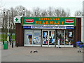
Britannia Pharmacy, Crossharbour ASDA
Tacked on to a hypermarket here.
Image: © Robin Webster
Taken: 5 Mar 2011
0.08 miles
8
Jubilee Gardens
327-355 & 327a-355a Manchester Road, E14
Image: © Peter Thwaite
Taken: 19 Dec 2008
0.10 miles
9
Paddock, Mudchute Farm, Cubitt Town, London, E14
Some maps and local plans have this field marked as the "lower paddock" although currently it appears to be being used as a playing field and it also sports some playground equipment. The multi-storey buildings seem likely to be situated on the other side of the A1206 (a.k.a. Manchester Road).
Image: © David Hallam-Jones
Taken: 2 Apr 2016
0.10 miles
10
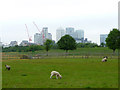
Mudchute Farm, Isle of Dogs
Lambs at Mudchute Farm with the Canary Wharf Towers in the background.
Image: © Christine Matthews
Taken: 13 May 2009
0.11 miles