IMAGES TAKEN NEAR TO
Manchester Road, LONDON, E14 3HW
Introduction
This page details the photographs taken nearby to Manchester Road, E14 3HW by members of the Geograph project.
The Geograph project started in 2005 with the aim of publishing, organising and preserving representative images for every square kilometre of Great Britain, Ireland and the Isle of Man.

There are currently over 7.5m images from over14,400 individuals and you can help contribute to the project by visiting https://www.geograph.org.uk
Image Map (Loading...)


Getting Data...Please wait
Leaflet Map data © OpenStreetMap
Images are licensed for reuse under creativecommons.org/licenses/by-sa/2.0
Notes
- Clicking on the map will re-center to the selected point.
- The higher the marker number, the further away the image location is from the centre of the postcode.
Image Listing (102 Images Found)
Images are licensed for reuse under creativecommons.org/licenses/by-sa/2.0
Image
Details
Distance
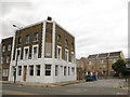
1
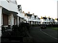
Jubilee Gardens
327-355 & 327a-355a Manchester Road, E14
Image: © Peter Thwaite
Taken: 19 Dec 2008
0.04 miles
2
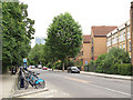
Cycle docking station, Manchester Road, Cubitt Town
At this time they were still Barclay Bikes (by the following year they were rebranded in red as Santander Cycles).
Image: © Stephen Craven
Taken: 15 Jun 2014
0.06 miles
3
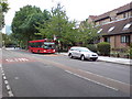
Manchester Road, E14
Near the junction with Friars Mead. A D3 bus is on its way to Bethnal Green.
Image: © Danny P Robinson
Taken: 27 Aug 2009
0.06 miles
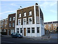
5
The former Cubitt Arms, Olliffe Street
The pub has closed since a previous contributor's photo in 2009 Image Presumably named after William Cubitt who developed the area (source: https://en.wikipedia.org/wiki/Cubitt_Town )
Image: © Stephen Craven
Taken: 15 Jun 2014
0.06 miles
6
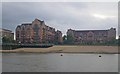
Vermeer Court and Van Gogh Court from Blackwall Reach
The waterfront scene is along the north bank of the River Thames. Photographer is onboard a vessel upon the Thames.
Image: © C Michael Hogan
Taken: 31 Jul 2012
0.08 miles
7
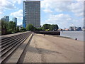
Beach at Blackwall Reach, Isle of Dogs
The beach and Thames path can be reached from nearby Amsterdam Road. The tower block in the background is Kelson House.
Image: © Danny P Robinson
Taken: 21 Jun 2009
0.08 miles
8
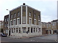
The Cubitt Arms Pub, Cubitt Town
At the corner of Manchester Road and Olliffe Street, E14
Image: © Danny P Robinson
Taken: 27 Aug 2009
0.09 miles
9
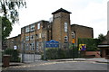
Cubitt Town Junior and Infant Schools
At the east end of Glengall Grove.
Image: © Dr Neil Clifton
Taken: 14 Jun 2012
0.11 miles
10
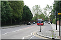
Cubitt Town: Manchester Road
Looking south from the end of Marshfield Street. The single-deck bus is Stagecoach No 36348, and is on Route D3, a local Doclands service.
Image: © Dr Neil Clifton
Taken: 14 Jun 2012
0.11 miles