IMAGES TAKEN NEAR TO
Manchester Road, LONDON, E14 3DP
Introduction
This page details the photographs taken nearby to Manchester Road, E14 3DP by members of the Geograph project.
The Geograph project started in 2005 with the aim of publishing, organising and preserving representative images for every square kilometre of Great Britain, Ireland and the Isle of Man.

There are currently over 7.5m images from over14,400 individuals and you can help contribute to the project by visiting https://www.geograph.org.uk
Image Map (Loading...)


Getting Data...Please wait
Leaflet Map data © OpenStreetMap
Images are licensed for reuse under creativecommons.org/licenses/by-sa/2.0
Notes
- Clicking on the map will re-center to the selected point.
- The higher the marker number, the further away the image location is from the centre of the postcode.
Image Listing (165 Images Found)
Images are licensed for reuse under creativecommons.org/licenses/by-sa/2.0
Image
Details
Distance
1
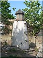
A feature located in Saunders Ness Park
This feature looks light a light beacon, but there are no historic records of navigational beacons here that I can find.
Further ideas would be appreciated.
Image: © Alan Reynolds
Taken: 30 Apr 2007
0.01 miles
2

The windows in the tower, Saunders Ness Park
This photo shows more detail of the top of the light tower, but the feature is much more overgrown two years later
Image: © Alan Reynolds
Taken: 4 Jul 2009
0.02 miles
3
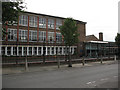
St Luke's Primary School, Cubitt Town
The main buildings of the school on Saunders Ness Road.
Image: © Stephen Craven
Taken: 29 Jul 2010
0.05 miles
4
St Luke's Early Years Centre
Image: © Stephen Craven
Taken: 29 Jul 2010
0.05 miles
5
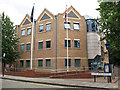
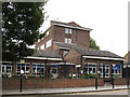
Cubitt Town Police Station
A fairly new building on Manchester Road.
Image: © Stephen Craven
Taken: 29 Jul 2010
0.06 miles
8
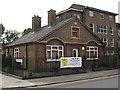
St Luke's School House
The gates outside this building on the corner of Saunders Ness Road and Glenworth Avenue bear the SBL monogram (School Board for London) which dates it between 1870-1904. It is currently a "job shop".
Image: © Stephen Craven
Taken: 29 Jul 2010
0.06 miles
9
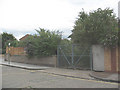
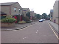
Site of Saunders Ness Park
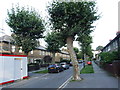
According to a local resident, this currently locked and overgrown site on the corner of Glenworth Avenue (foreground) and Saunders Ness Road was, about 25 years ago, an attractive little park planted and maintained by local volunteers. But it gradually became neglected. The site was apparently sold to developers several years ago but has not been built on as several planning applications have been rejected. There is allegedly a monument in the "park" to a local resident, but it was not visible through the tangled undergrowth.
Image: © Stephen Craven
Taken: 29 Jul 2010
0.07 miles