IMAGES TAKEN NEAR TO
Newport Avenue, LONDON, E14 2DS
Introduction
This page details the photographs taken nearby to Newport Avenue, E14 2DS by members of the Geograph project.
The Geograph project started in 2005 with the aim of publishing, organising and preserving representative images for every square kilometre of Great Britain, Ireland and the Isle of Man.

There are currently over 7.5m images from over14,400 individuals and you can help contribute to the project by visiting https://www.geograph.org.uk
Image Map
Images are licensed for reuse under creativecommons.org/licenses/by-sa/2.0
Notes
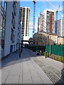
- Clicking on the map will re-center to the selected point.
- The higher the marker number, the further away the image location is from the centre of the postcode.
Image Listing (269 Images Found)
Images are licensed for reuse under creativecommons.org/licenses/by-sa/2.0
Image
Details
Distance
2
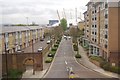
Housing Construction and Prime Meridian, London
This shows high rise apartments being built close to the river Thames in Blackwall , east London. On the pavement the prime meridian is marked with a checkerboard of small tiles and a brass strip. A blue line of tiles has also been put on the low rise white building in the middle distance to mark the meridian. This view is due north along the meridian.
Image: © Nigel Mykura
Taken: 12 Jan 2008
0.03 miles
3
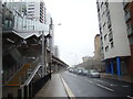
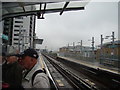
View up Blackwall Way
Looking north-northeast from outside East India DLR station.
Image: © Robert Lamb
Taken: 8 Oct 2012
0.04 miles
4
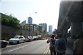
View along Blackwall Way
Looking south-southwest.
Image: © Robert Lamb
Taken: 5 Jun 2016
0.04 miles
5
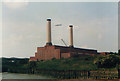
Brunswick Wharf Power Station
This picture was taken from TQ392811 which was where I was working at the time. The Financial Times building now occupies the power station site (more or less). This area has changed almost beyond recognition over the past 20 years
Image: © Ian M
Taken: Unknown
0.05 miles
6
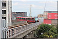
View north-northeast from East India station
Looking north-northeast.
Image: © Robert Lamb
Taken: 8 Oct 2012
0.06 miles
7
Docklands Light Railway, East India
Image: © Oast House Archive
Taken: 26 Jun 2014
0.06 miles
8
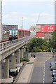
Docklands Light Railway, East India
Image: © Oast House Archive
Taken: 26 Jun 2014
0.06 miles
9
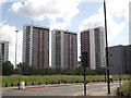
Elektron Towers, Blackwall
Three of the four large modern apartment buildings built by Barratt homes, between East India Dock Way and the Docklands Light Railway.
Two are called Proton Tower and Neutron Tower!
In the foreground is Sorrel Lane.
Image: © David Anstiss
Taken: 5 Jul 2012
0.06 miles
10
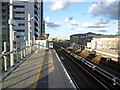
East India DLR station
East India DLR station takes its name from the nearby former East India Docks where ships trading with the Indian subcontinent used to dock. East India Dock is now a nature reserve and is visible from the DLR on the right hand side between East India and Canning Town. The station opened as part of the Beckton Branch, on 28th March 1994. The Greenwich Meridian line crosses the DLR just to the east of the platforms, and a small trackside sign indicates this. East India station was originally to be named Brunswick Wharf and this name was shown on the 1994 'all projections' map.
Image: © Marathon
Taken: 11 May 2012
0.06 miles