IMAGES TAKEN NEAR TO
City Island Way, LONDON, E14 0TN
Introduction
This page details the photographs taken nearby to City Island Way, E14 0TN by members of the Geograph project.
The Geograph project started in 2005 with the aim of publishing, organising and preserving representative images for every square kilometre of Great Britain, Ireland and the Isle of Man.

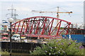
There are currently over 7.5m images from over14,400 individuals and you can help contribute to the project by visiting https://www.geograph.org.uk
Image Map (Loading...)


Getting Data...Please wait
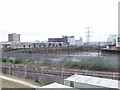
Leaflet Map data © OpenStreetMap
Images are licensed for reuse under creativecommons.org/licenses/by-sa/2.0
Notes
- Clicking on the map will re-center to the selected point.
- The higher the marker number, the further away the image location is from the centre of the postcode.
Image Listing (369 Images Found)
Images are licensed for reuse under creativecommons.org/licenses/by-sa/2.0
Image
Details
Distance
1
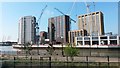
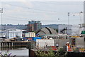
New construction across the River Lea
Seen from platform 4 of Canning Town station.
Image: © David Martin
Taken: 7 Apr 2017
0.01 miles
2
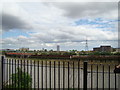
View of Canning Town Station from the Bow Creek Ecology Park path
Looking northeast.
Image: © Robert Lamb
Taken: 8 May 2011
0.01 miles
3
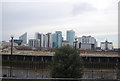
Dockland financial centre, across Bow Creek from Canning Town Station
Image: © N Chadwick
Taken: 20 Jan 2009
0.01 miles
4
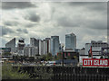
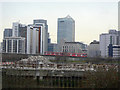
City Island as seen from Canning Town, London
The tower blocks of Canary Wharf can be seen in the distance, behind London's newest island.
Image: © Christine Matthews
Taken: 26 Sep 2014
0.02 miles
5
Bridge construction, Leamouth Peninsula
Image: © Oast House Archive
Taken: 26 Jun 2014
0.02 miles
6
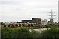
Construction site, Leamouth Peninsula
Image: © Oast House Archive
Taken: 26 Jun 2014
0.02 miles
7
A pile of rubble
February 2009, and the title might be thought to refer to the edifices in the distance occupied by the crumbling banking industry.
In fact it is referring to the heap in the foreground, the last remains of the old margarine factory in the bend of the Bow Creek. Its demise does however now open up the view of the DLR viaduct climbing up towards Blackwall.
Image: © Alan Murray-Rust
Taken: 12 Feb 2009
0.03 miles
8
Beside the River Lea (or Lee) at Canning Town
A DLR train is in the process of leaving the high level platforms at Canning Town station. The river itself has just passed the head of its second and final meander before reaching the Thames.
Image: © David Kemp
Taken: 1 Jul 2010
0.03 miles
9
A View From Canning Town Station
Taken from DLR Platform 3 looking SSW. The person in the photo got in the way!
Image: © Claire Ward
Taken: 2 Jun 2005
0.03 miles
10
Bow Creek, Canning Town
Bow Creek is the lower end of the River Lea. This view is south-east from the end of East India Dock Road, across the loop of the river to Canning Town Station.
Image: © David Hawgood
Taken: 21 Mar 2006
0.03 miles