IMAGES TAKEN NEAR TO
Botanic Square, LONDON, E14 0LH
Introduction
This page details the photographs taken nearby to Botanic Square, E14 0LH by members of the Geograph project.
The Geograph project started in 2005 with the aim of publishing, organising and preserving representative images for every square kilometre of Great Britain, Ireland and the Isle of Man.

There are currently over 7.5m images from over14,400 individuals and you can help contribute to the project by visiting https://www.geograph.org.uk
Image Map
Images are licensed for reuse under creativecommons.org/licenses/by-sa/2.0
Notes
- Clicking on the map will re-center to the selected point.
- The higher the marker number, the further away the image location is from the centre of the postcode.
Image Listing (467 Images Found)
Images are licensed for reuse under creativecommons.org/licenses/by-sa/2.0
Image
Details
Distance
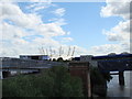
1
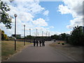
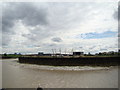
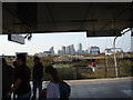
View of the O2 from the riverside path opposite Bow Creek
Looking south.
Image: © Robert Lamb
Taken: 8 May 2011
0.01 miles
2
View of the O2 from the A13
Looking south.
Image: © Robert Lamb
Taken: 8 May 2011
0.02 miles
3
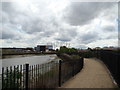
View of the O2 from the Bow Creek Ecology Park path #2
Looking south, this time with more of the river in shot.
Image: © Robert Lamb
Taken: 8 May 2011
0.03 miles
5
View of the O2 from the Bow Creek Ecology Park path #3
Looking south-southeast.
Image: © Robert Lamb
Taken: 8 May 2011
0.03 miles
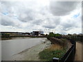
6
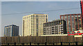
London City Island
A view from the DLR just south of Canning Town station of the transformed Leamouth Peninsula on the River Lea.
Image: © Derek Harper
Taken: 17 Apr 2019
0.03 miles
7
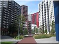
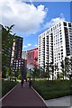
London City Island: Botanic Square, E14
This is the central plaza of the new London City Island development, on the Leamouth Peninsula.
From a geographical point of view it is not an island at all, but a spur of land that the tidal River Lee has meandered around, with the neck about 85 metres wide at its narrowest point.
For a photograph of the site taken in 2008 by myself, when construction work was just commencing, please see Image
Image: © Nigel Cox
Taken: 29 Aug 2019
0.03 miles
8
View of the O2 from the Bow Creek Ecology Park path
Looking south.
Image: © Robert Lamb
Taken: 8 May 2011
0.03 miles
9
View of Canary Wharf from Canning Town Station
Looking south-southwest.
Image: © Robert Lamb
Taken: 23 Oct 2011
0.04 miles
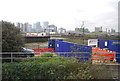
10
London City Island
A new 12 acre development between Canning Town Station to the north and East India Dock Basin to the south.
Image: © Trevor Harris
Taken: 21 Jun 2020
0.04 miles