IMAGES TAKEN NEAR TO
Hope Street, LONDON, E14 0BZ
Introduction
This page details the photographs taken nearby to Hope Street, E14 0BZ by members of the Geograph project.
The Geograph project started in 2005 with the aim of publishing, organising and preserving representative images for every square kilometre of Great Britain, Ireland and the Isle of Man.

There are currently over 7.5m images from over14,400 individuals and you can help contribute to the project by visiting https://www.geograph.org.uk
Image Map
Images are licensed for reuse under creativecommons.org/licenses/by-sa/2.0
Notes
- Clicking on the map will re-center to the selected point.
- The higher the marker number, the further away the image location is from the centre of the postcode.
Image Listing (409 Images Found)
Images are licensed for reuse under creativecommons.org/licenses/by-sa/2.0
Image
Details
Distance
1
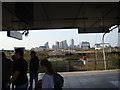
View of Canary Wharf from Canning Town Station
Looking south-southwest.
Image: © Robert Lamb
Taken: 23 Oct 2011
0.00 miles
3
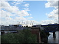
View of the O2 from the Bow Creek Ecology Park path
Looking south.
Image: © Robert Lamb
Taken: 8 May 2011
0.02 miles
4
View of the Lower Lea Crossing from the Bow Creek Ecology Park path
Looking southeast.
Image: © Robert Lamb
Taken: 8 May 2011
0.02 miles
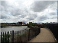
5
View of the O2 from the riverside path opposite Bow Creek
Looking south.
Image: © Robert Lamb
Taken: 8 May 2011
0.03 miles
6
View of the O2 from the Bow Creek Ecology Park path #3
Looking south-southeast.
Image: © Robert Lamb
Taken: 8 May 2011
0.03 miles
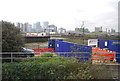
7
View of RMS plc from East India Dock
RMS stands for Road Management Services. This is the branch of the company that deals with maintenance and management of the nearby A13. Looking northeast from East India Dock.
Image: © Robert Lamb
Taken: 8 May 2011
0.04 miles
8
View of the O2 from the Bow Creek Ecology Park path #2
Looking south, this time with more of the river in shot.
Image: © Robert Lamb
Taken: 8 May 2011
0.04 miles
9
View of the O2 from the A13
Looking south.
Image: © Robert Lamb
Taken: 8 May 2011
0.04 miles
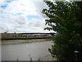
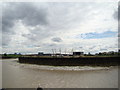
10
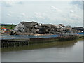
Demolition near the River Lea
Picture taken from Bow Creek Ecology Park, east side. I don't know what this factory used to make, nor do I know what will be put here instead. Google Maps Satellite View shows this peninsula as being covered with industry but it is looking very bare now, with just this remaining.
Image: © Danny P Robinson
Taken: 20 May 2007
0.04 miles