IMAGES TAKEN NEAR TO
First Avenue, LONDON, E13 8AP
Introduction
This page details the photographs taken nearby to First Avenue, E13 8AP by members of the Geograph project.
The Geograph project started in 2005 with the aim of publishing, organising and preserving representative images for every square kilometre of Great Britain, Ireland and the Isle of Man.

There are currently over 7.5m images from over14,400 individuals and you can help contribute to the project by visiting https://www.geograph.org.uk
Image Map
Images are licensed for reuse under creativecommons.org/licenses/by-sa/2.0
Notes
- Clicking on the map will re-center to the selected point.
- The higher the marker number, the further away the image location is from the centre of the postcode.
Image Listing (71 Images Found)
Images are licensed for reuse under creativecommons.org/licenses/by-sa/2.0
Image
Details
Distance
3
Houses on First and Second Avenues, Plaistow E13
Image: © Robin Webster
Taken: 11 Dec 2010
0.07 miles


7
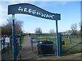
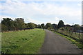
The Greenway above the Northern Outfall Sewer
By the 1850s the River Thames in Central London was a vast open sewer and “The Great Stink” of 1855 brought matters to a head. The smell was so strong that curtains soaked in calcium chloride had to be hung over the windows of the Houses of Parliament facing the river. The Government finally acknowledged the problem and established the Metropolitan Board of Works. Their first task was the provision of a proper sewerage and drainage system. The Northern and Southern Outfall Sewers were constructed between 1860 and 1865, the former carrying sewage from northern London to the Northern Outfall Works at Beckton.
The Greenway has been opened up on top as a footway and cycle track and runs all the way from Victoria Park to Beckton. The Capital Ring follows most of it. Here it is seen from Balaam Street.
Image: © Marathon
Taken: 10 Mar 2015
0.08 miles
8
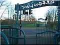
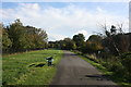
Greenway
The Greenway provides a traffic-free walking and cycling route for a few miles through one of the most densely populated areas of east London. It runs from the Old Ford to Becton, over the top of the Northern Outfall Sewer. The many road crossings are protected with lights and are gated to prevent motorised access. Here Greenway crosses Balaam Street, Plaistow.
Image: © John Davies
Taken: 21 Jan 2006
0.10 miles
10
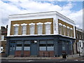
The Earl of Derby Public House, Plaistow
Former Grade II listed public house on the junction of London Road (on the left) and Chesterton Road.
See http://www.britishlistedbuildings.co.uk/en-479937-the-earl-of-derby-public-house-greater-l for more details about the listed building.
Image: © David Anstiss
Taken: 26 Aug 2012
0.12 miles