IMAGES TAKEN NEAR TO
Solomon Way, LONDON, E1 0FA
Introduction
This page details the photographs taken nearby to Solomon Way, E1 0FA by members of the Geograph project.
The Geograph project started in 2005 with the aim of publishing, organising and preserving representative images for every square kilometre of Great Britain, Ireland and the Isle of Man.

There are currently over 7.5m images from over14,400 individuals and you can help contribute to the project by visiting https://www.geograph.org.uk
Image Map
Images are licensed for reuse under creativecommons.org/licenses/by-sa/2.0
Notes
- Clicking on the map will re-center to the selected point.
- The higher the marker number, the further away the image location is from the centre of the postcode.
Image Listing (207 Images Found)
Images are licensed for reuse under creativecommons.org/licenses/by-sa/2.0
Image
Details
Distance
1
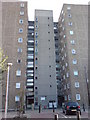
Allonby House, Stepney
When built, this would have been a better place to live than any of the realistic alternatives that would have existed for tenants at the time. But now, it just looks like a grim place to live.
Somebody has posted many more photos of this on Flickr http://www.flickr.com/photos/almodozo/2584382013/
Image: © Danny P Robinson
Taken: 25 Sep 2009
0.05 miles
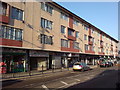
4
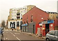
Aston Road, Stepney
On the right is Steptoe and Son, its parking protected by an assortment of chairs. Beyond the Chicken Mahal takeaway and across Ben Jonson Road is a new block, Mercer Court.
Image: © Derek Harper
Taken: 1 Feb 2011
0.05 miles
5
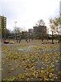
Stepney, adventure playground
Whitehorse Adventure Playground, on White Horse Road; not a lot going on.
Image: © Mike Faherty
Taken: 30 Nov 2013
0.05 miles
6
Shops and Flats, Ben Jonson Road, E1
Ben Jonson was an English Renaissance dramatist, poet and actor.
Image: © Danny P Robinson
Taken: 25 Sep 2009
0.06 miles
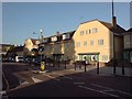
7
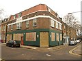
Former pub, Stepney
The shuttered building is on the corner of Durham Row (right - the terrace is listed http://www.britishlistedbuildings.co.uk/en-205930-3-19-stepney ) and Whitehorse Road. Can anyone identify the symbol on the upper left side? It appears to be a pair of wings on either side of a tower, with the date 1757.
Image: © Derek Harper
Taken: 1 Feb 2011
0.07 miles
9
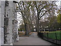
Path through St Dunstan's Churchyard
With mature plane trees
Image: © Dr Neil Clifton
Taken: 7 Nov 2007
0.09 miles
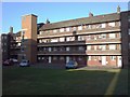
10
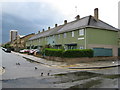
Stepney: Limehouse Fields Estate, E14
Stepney suffered greatly during the Blitz, and there was a desperate need in the immediate post-war years not only to re-house people whose homes had been destroyed but also to cater for demobilized service personnel returning home to civilian life. The Limehouse Fields Estate was one of the main developments to solve these problems. Three different types of housing can be seen here. The nearest, and somewhat unusually green, houses are Donoghue Cottages, built in 1949. Further down the road, which is Galsworthy Avenue, are some more recent (1990s?) houses, while in the distance is a towerblock, probably dating from the 1960s.
Image: © Nigel Cox
Taken: 1 May 2008
0.09 miles