IMAGES TAKEN NEAR TO
Eastgate Business Park, Argall Way, LONDON, E10 7PG
Introduction
This page details the photographs taken nearby to Eastgate Business Park, Argall Way, E10 7PG by members of the Geograph project.
The Geograph project started in 2005 with the aim of publishing, organising and preserving representative images for every square kilometre of Great Britain, Ireland and the Isle of Man.

There are currently over 7.5m images from over14,400 individuals and you can help contribute to the project by visiting https://www.geograph.org.uk
Image Map
Images are licensed for reuse under creativecommons.org/licenses/by-sa/2.0
Notes
- Clicking on the map will re-center to the selected point.
- The higher the marker number, the further away the image location is from the centre of the postcode.
Image Listing (93 Images Found)
Images are licensed for reuse under creativecommons.org/licenses/by-sa/2.0
Image
Details
Distance
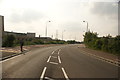
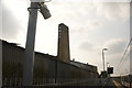
1
View up Argall Way from outside Lea Bridge station
Looking north-northwest.
Image: © Robert Lamb
Taken: 28 May 2016
0.05 miles
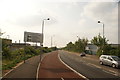
2
View along Argall Way
Looking north-northwest.
Image: © Robert Lamb
Taken: 28 May 2016
0.07 miles
3

View of the new Lea Bridge station from Argall Way #3
Looking north-northwest.
Image: © Robert Lamb
Taken: 28 May 2016
0.08 miles
4
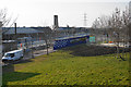
Lea Bridge Station
On the railway line between Stratford and Tottenham Hale, it is still under construction in this view taken in March. It is due to open in a couple of days time on 15th May 2016.
Image: © Bill Boaden
Taken: 17 Mar 2016
0.09 miles
5

View of the new Lea Bridge station from Argall Way #2
Looking south-southwest.
Image: © Robert Lamb
Taken: 28 May 2016
0.09 miles
6

View up the ramp at the new Lea Bridge station
Looking north-northwest.
Image: © Robert Lamb
Taken: 28 May 2016
0.09 miles
7
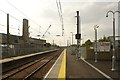
View along the platform at Lea Bridge station
Looking north-northwest.
Image: © Robert Lamb
Taken: 28 May 2016
0.09 miles
8

View along the Abellio Greater Anglia line towards Stratford #2
Looking south-southeast.
Image: © Robert Lamb
Taken: 28 May 2016
0.09 miles
9
View of a factory chimney from the new Lea Bridge railway station
Lea Bridge station opened just three weeks ago, marking 31 years since the original station was demolished in 1985. Looking south-southwest.
Image: © Robert Lamb
Taken: 28 May 2016
0.10 miles
10
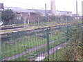
Platforms of the disused Lea Bridge station
Lea Bridge station was opened on 15th September 1840 by the Northern & Eastern Railway as Lea Bridge Road and is thought to be the earliest example of a station having its building on a railway bridge, with staircases down to the platforms. The station buildings were demolished in the 1970s and the station itself closed on 8th July 1985.
Closure was not the end of the story though as in December 2005, a new service between Stratford and Stansted Airport reintroduced regular passenger trains through the closed station and within the next year or so a new station will be opened here. The new station though will be on the south side of Lea Bridge Road, rather than the north side where the old station was located.
There is so much information on the historic old Lea Bridge station that it is best to just show links to the many sites with photographs and its history. See http://en.wikipedia.org/wiki/Lea_Bridge_railway_station and http://www.abandonedstations.org.uk/North_Woolwich_line_1.html and http://www.londonreconnections.com/2013/lea-bridge-lives-again/ and http://www.disused-stations.org.uk/l/lea_bridge/
Image: © Marathon
Taken: 19 Nov 2014
0.10 miles