IMAGES TAKEN NEAR TO
Sedgwick Road, LONDON, E10 6QP
Introduction
This page details the photographs taken nearby to Sedgwick Road, E10 6QP by members of the Geograph project.
The Geograph project started in 2005 with the aim of publishing, organising and preserving representative images for every square kilometre of Great Britain, Ireland and the Isle of Man.

There are currently over 7.5m images from over14,400 individuals and you can help contribute to the project by visiting https://www.geograph.org.uk
Image Map (69 Images)


Getting Data...Please wait
Leaflet Map data © OpenStreetMap
Images are licensed for reuse under creativecommons.org/licenses/by-sa/2.0
Notes
- Clicking on the map will re-center to the selected point.
- The higher the marker number, the further away the image location is from the centre of the postcode.
Image Listing (69 Images Found)
Images are licensed for reuse under creativecommons.org/licenses/by-sa/2.0
Image
Details
Distance
1
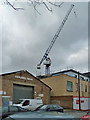
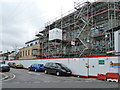
Forward Hous
The presumption that an 'E' has dropped off may be incorrect - if so, the name would not be very well centred. It was a gusty day, as the crane hook beyond indicates.
Image: © Robin Webster
Taken: 15 Jan 2011
0.11 miles
2
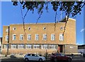
Met House
Met House - the old police station in Francis Road, Leyton.
Image: © Alan Hughes
Taken: 18 Jan 2020
0.11 miles
3
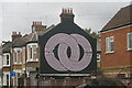
View of a mural on the side of 2a Claude Road
Looking north-northeast.
Image: © Robert Lamb
Taken: 27 Sep 2020
0.12 miles
4
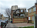
Building site, E10
Flats facing Buckland Road.
Image: © Robin Webster
Taken: 15 Jan 2011
0.12 miles
5
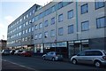
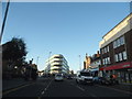
Flats from Sedgewick Road, E10
These are above and behind shops on High Road, Leyton.
Image: © Robin Webster
Taken: 15 Jan 2011
0.12 miles