IMAGES TAKEN NEAR TO
Brake Lane, STOURBRIDGE, DY8 2XP
Introduction
This page details the photographs taken nearby to Brake Lane, DY8 2XP by members of the Geograph project.
The Geograph project started in 2005 with the aim of publishing, organising and preserving representative images for every square kilometre of Great Britain, Ireland and the Isle of Man.

There are currently over 7.5m images from over14,400 individuals and you can help contribute to the project by visiting https://www.geograph.org.uk
Image Map
Images are licensed for reuse under creativecommons.org/licenses/by-sa/2.0
Notes
- Clicking on the map will re-center to the selected point.
- The higher the marker number, the further away the image location is from the centre of the postcode.
Image Listing (7 Images Found)
Images are licensed for reuse under creativecommons.org/licenses/by-sa/2.0
Image
Details
Distance
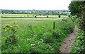
1
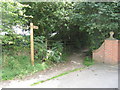
Monarch?s Way Footpath from Brake Lane to Brake Mill Farm, Worcestershire
This walk follows the escape of Charles II after the Battle of Worcester in 1651. http://www.walkingpages.co.uk/trails_paths/LDP_monarchsway.htm
Image: © Richard Rogerson
Taken: 15 Aug 2009
0.06 miles
3
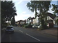
Brake Lane
The view down the Hagley Lane.
Image: © Gordon Griffiths
Taken: 8 Oct 2011
0.16 miles
4
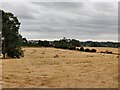
Bridleway and Fields, Palmer's Hill, Worcestershire
The farmland locally is shared between grazing (mainly horses and sheep) and crops (cereals, rape and potatoes). On this Saturday the bridleways were being well used by horse riders.
Image: © Roger Kidd
Taken: 19 May 2007
0.22 miles
5
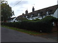
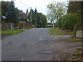
Brake Lane Cottages
The view in the Hagley Lane.
Image: © Gordon Griffiths
Taken: 8 Oct 2011
0.22 miles
6
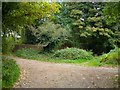
Junction of paths
Just below the top of Palmer's hill
Image: © Stephen Rogerson
Taken: 25 Oct 2016
0.22 miles