IMAGES TAKEN NEAR TO
Harrold Street, TIPTON, DY4 0JF
Introduction
This page details the photographs taken nearby to Harrold Street, DY4 0JF by members of the Geograph project.
The Geograph project started in 2005 with the aim of publishing, organising and preserving representative images for every square kilometre of Great Britain, Ireland and the Isle of Man.

There are currently over 7.5m images from over14,400 individuals and you can help contribute to the project by visiting https://www.geograph.org.uk
Image Map
Images are licensed for reuse under creativecommons.org/licenses/by-sa/2.0
Notes
- Clicking on the map will re-center to the selected point.
- The higher the marker number, the further away the image location is from the centre of the postcode.
Image Listing (23 Images Found)
Images are licensed for reuse under creativecommons.org/licenses/by-sa/2.0
Image
Details
Distance
1
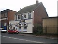
The Dew Drop Inn, Toll End Road
A Banks's pub near Toll End.
Image: © Richard Law
Taken: 4 Dec 2009
0.06 miles
2
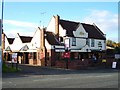
The Kings Arms Tipton
info http://www.marstonspubs.co.uk/thekingsarms/
Image: © Stephen Rogerson
Taken: 7 Nov 2013
0.12 miles
3
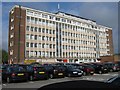
Eon Distribution Centre, Tipton
View from car park of main building on Toll End Road
Image: © Michael Westley
Taken: 14 May 2010
0.14 miles
4
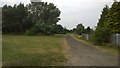
Path on line of former Toll End Canal
This pathway skirts the northern edge of Tipton Cemetery along the line of the Toll End Canal, filled in after it closed in the 1960s. The view is from Bridge Road at the former site of the canal bridge. The gardens of houses to the right of the view were developed decades ago on part of the site of the Cotterill Farm Colliery.
Image: © Paul Collins
Taken: 18 Aug 2016
0.15 miles
5

Entrance to Tipton Cemetery
This roadway has been attractively landscaped in recent years to improve the approach to the cemetery off Bridge Road. The photo is taken from the Bridge Road and the Aston Street junction. The small roundabout in the middle distance is approximately the site of an old Smallpox Hospital.
Image: © Paul Collins
Taken: 18 Aug 2016
0.17 miles
6

Bayleys Pool, Toll End Road, Tipton
Landscaped border and Bayleys Pool beyond, in grounds of EON offices / site.
Bayleys Pool is around 1.3 hectares in size, roughly circular in shape, steep sided and more than 6 metres at its deepest point. The pool is over 70 years old and was formed from and old marl pit. It is surrounded by a narrow, intermittent fringe of scrub and more than 50% of the pool is shaded.
Bayleys Pool, once a quarry, was formerly dug for brick clay supplying the adjacent Crown Brick Works. The clays were part of the Etruria Formation of Carboniferous age. Image]
Image: © Michael Westley
Taken: 17 May 2010
0.18 miles
7
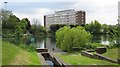
Bayleys Pool, Tipton
View from grounds of EON training centre, of the pool, and main Tipton Distribution Centre beyond Image]
Image: © Michael Westley
Taken: 21 May 2010
0.18 miles
8
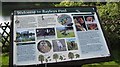
Bayleys Pool information board
In grounds of EON offices / site, information board on side of pool landscaped Image]
Image: © Michael Westley
Taken: 17 May 2010
0.20 miles
9
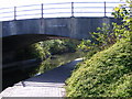
Moors Mill Lane Bridge
A Bridge over the Walsall Canal near Great Bridge.
Image: © Gordon Griffiths
Taken: 29 Apr 2009
0.21 miles
10
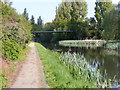
Walsall Canal View
The Canal near the Black Country New Road at Great Bridge.
Image: © Gordon Griffiths
Taken: 29 Apr 2009
0.21 miles