IMAGES TAKEN NEAR TO
Long Common, DUDLEY, DY3 4PY
Introduction
This page details the photographs taken nearby to Long Common, DY3 4PY by members of the Geograph project.
The Geograph project started in 2005 with the aim of publishing, organising and preserving representative images for every square kilometre of Great Britain, Ireland and the Isle of Man.

There are currently over 7.5m images from over14,400 individuals and you can help contribute to the project by visiting https://www.geograph.org.uk
Image Map
Images are licensed for reuse under creativecommons.org/licenses/by-sa/2.0
Notes
- Clicking on the map will re-center to the selected point.
- The higher the marker number, the further away the image location is from the centre of the postcode.
Image Listing (37 Images Found)
Images are licensed for reuse under creativecommons.org/licenses/by-sa/2.0
Image
Details
Distance
1
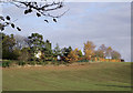
Cropfield and farm near Halfpenny Green, Staffordshire
Seen from the footpath by the quarry. The farm is called The Eaves. The winter wheat (or similar) crop appears to be growing well. The soil colour shows the tint of underlying Triassic sandstone. Late afternoon autumn sunlight is adding a golden cast to the scene.
Image: © Roger D Kidd
Taken: 11 Nov 2012
0.02 miles
2
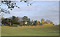
Cropfield and farm near Halfpenny Green, Staffordshire
Seen from the footpath by the quarry. The farm is called The Eaves. The winter wheat (or similar) crop appears to be growing well. Late afternoon autumn sunlight is adding a golden cast to the scene.
Image: © Roger D Kidd
Taken: 11 Nov 2012
0.04 miles
3
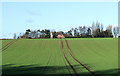
Crop Field west of Wombourne, Staffordshire
The Eaves is the farm on the crest of the hill.
Image: © Roger D Kidd
Taken: 30 Jan 2008
0.09 miles
4
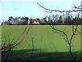
Crop Field west of Wombourne, Staffordshire
The farmhouse on the skyline is called The Eaves.
Image: © Roger D Kidd
Taken: 30 Jan 2008
0.10 miles
5
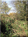
Public footpath near Halfpenny Green, Staffordshire
The Staffordshire Way climbs this somewhat overgrown way towards Abbot's Castle Hill. A deep (apparently mothballed) sandstone quarry is off to the left (west).
http://www.staffordshire.gov.uk/environment/eLand/RightsofWay/PromotedRoutes/StaffordshireWay.aspx
Image: © Roger D Kidd
Taken: 11 Nov 2012
0.11 miles
6
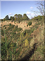
Sandstone rock near Halfpenny Green, Staffordshire
Not much seems to be happening in this quarry currently. The rock is Triassic Bunter Sandstone. http://en.wikipedia.org/wiki/Bunter_%28geology%29
Image: © Roger D Kidd
Taken: 11 Nov 2012
0.12 miles
7
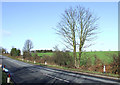
Farmland, and B4176 to Bridgnorth
This is a B road, but can be a busy one with fast traffic. Links Dudley with Bridgnorth. Arable farming is dominant round here.
Image: © Roger D Kidd
Taken: 30 Jan 2008
0.12 miles
8
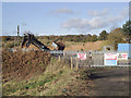
Quarry gateway near Halfpenny Green, Staffordshire
Although notices warn that this is a working quarry, not much seems to be happening currently. The rock is Bunter Sandstone (Triassic).
Image]
Image: © Roger D Kidd
Taken: 11 Nov 2012
0.14 miles
9
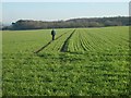
Field Path
The Path from Clan Park towards the Bridgnorth Road.
Image: © Gordon Griffiths
Taken: 11 Feb 2008
0.14 miles
10
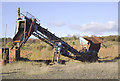
Quarry machinery near Halfpenny Green, Staffordshire
Not a great deal seems to be happening at this sandstone quarry at present. The rock is (Triassic) Bunter Sandstone.
Image: © Roger D Kidd
Taken: 11 Nov 2012
0.14 miles