IMAGES TAKEN NEAR TO
Stonepine Place, DUDLEY, DY3 1TR
Introduction
This page details the photographs taken nearby to Stonepine Place, DY3 1TR by members of the Geograph project.
The Geograph project started in 2005 with the aim of publishing, organising and preserving representative images for every square kilometre of Great Britain, Ireland and the Isle of Man.

There are currently over 7.5m images from over14,400 individuals and you can help contribute to the project by visiting https://www.geograph.org.uk
Image Map
Images are licensed for reuse under creativecommons.org/licenses/by-sa/2.0
Notes
- Clicking on the map will re-center to the selected point.
- The higher the marker number, the further away the image location is from the centre of the postcode.
Image Listing (75 Images Found)
Images are licensed for reuse under creativecommons.org/licenses/by-sa/2.0
Image
Details
Distance
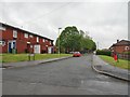
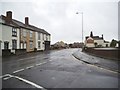
1
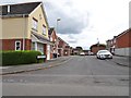
Stonepine Place
The view of the close off Valley Road in Woodsetton, Sedgley.
Image: © Gordon Griffiths
Taken: 25 May 2019
0.01 miles
2
Former Cinema
The view of the former Cinema on the corner of the Dudley Road and Valley Road, Sedgley. The former Coliseum is now a furniture Shop.
Image: © Gordon Griffiths
Taken: 5 Apr 2018
0.05 miles
3
Edmund Road
The view of the road off Valley Road in Woodsetton, Sedgley.
Image: © Gordon Griffiths
Taken: 25 May 2019
0.06 miles
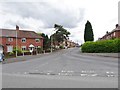
4
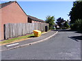
Wheatstone Close
The view of the Close off Downfield Drive in Sedgley, Dudley.
Image: © Gordon Griffiths
Taken: 30 Jun 2018
0.07 miles
5
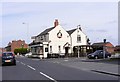
The Leopard
The Pub on the corner of the Dudley Road and Valley Road, Sedgley.
Image: © Gordon Griffiths
Taken: 4 Sep 2010
0.07 miles
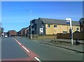
6
Jockey Field
The rainy view of the road off Tudor Road in Woodsetton, Sedgley.
Image: © Gordon Griffiths
Taken: 7 Jun 2019
0.08 miles
7
Winterley Gardens
The view of the Close off Downfield Drive in Sedgley, Dudley.
Image: © Gordon Griffiths
Taken: 30 Jun 2018
0.09 miles
8
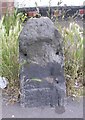
Old Milestone by the A459, Clarence Street in Upper Gornal
Stone post (plate lost) by the A459, in parish of Dudley (Dudley District), Clarence Street; Upper Gornal; 10m East of junction with Moden Hill, by No. 9, by the road, on East side of road. Erected by the Dudley & Wolverhampton turnpike trust in the 19th century.
Inscription once read:-
(Wolverhampton 4)
(Dudley 2)
Milestone Society National ID: ST_WVDL04
Image: © M Faherty
Taken: 11 Jun 2007
0.11 miles
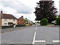
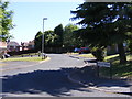
9
Moden Hill Junction
The junction with Clarence Street, Sedgley.
Image: © Gordon Griffiths
Taken: 4 Aug 2013
0.12 miles
10
Quarry Brow
The view of the road off Valley Road in Woodsetton, Sedgley.
Image: © Gordon Griffiths
Taken: 25 May 2019
0.12 miles