IMAGES TAKEN NEAR TO
Cleobury Mortimer, KIDDERMINSTER, DY14 8HN
Introduction
This page details the photographs taken nearby to DY14 8HN by members of the Geograph project.
The Geograph project started in 2005 with the aim of publishing, organising and preserving representative images for every square kilometre of Great Britain, Ireland and the Isle of Man.

There are currently over 7.5m images from over14,400 individuals and you can help contribute to the project by visiting https://www.geograph.org.uk
Image Map
Images are licensed for reuse under creativecommons.org/licenses/by-sa/2.0
Notes
- Clicking on the map will re-center to the selected point.
- The higher the marker number, the further away the image location is from the centre of the postcode.
Image Listing (8 Images Found)
Images are licensed for reuse under creativecommons.org/licenses/by-sa/2.0
Image
Details
Distance
1
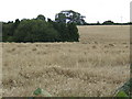
Barley field by the B4363
The trees are screening a farm building.
Image: © Jonathan Billinger
Taken: 30 Jul 2007
0.18 miles
2
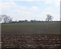
Ploughed field
Spring arable field beside the Wyre Forest. A nearby sign (across the grid line) states that a footpath here is closed "By Order". No information though, but a discrepancy between 1:25,000 and 1:50,000 mapping (no green pecked lines on the 1:25,000 map).
Image: © Richard Webb
Taken: 5 Apr 2015
0.21 miles
3
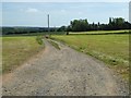
Track to Dinmore
Track or driveway to Dinmore near Neen Savage.
Image: © Philip Halling
Taken: 14 Jun 2017
0.21 miles
4
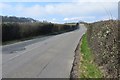
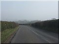
B4363 and bend
A very twisty and hilly road between Cleobury and Bridgnorth.
Image: © Richard Webb
Taken: 5 Apr 2015
0.23 miles
5
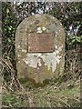
Old Milestone by the B4363, south of Wall Town, Neen Savage parish
Metal plate attached to stone post by the B4363, in parish of NEEN SAVAGE (BRIDGNORTH District), Walltown; 250m South of Walltown Farm, on the verge against hedge, on West side of road. Cleobury iron plate, erected by the Cleobury Mortimer to Bridgnorth turnpike trust in the 19th century.
Inscription reads:-
BRIDGNORTH
12 MILES
CLEOBURY MORTR
2 MILES
Carved benchmark front lower middle.
Shropshire HER.
HER Number (PRN): 21119 https://www.heritagegateway.org.uk/Gateway/Results_Single.aspx?uid=MSA23692&resourceID=1015
Milestone Society National ID: SA_BNCM12.
Image: © A Reade/M Faherty
Taken: 8 Feb 2008
0.23 miles
7
What the windscreens (and OS ) miss
An unmapped milestone near Wall Town on the B4363.
Image: © Richard Webb
Taken: 5 Apr 2015
0.24 miles
8
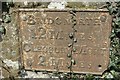
Milestone, Wall Town
Iron plaque on a stone in the hedge.
Bridgnorth 12m
Cleobury Mort. 2m
And a very hilly 12 miles it is.
Image: © Richard Webb
Taken: 5 Apr 2015
0.24 miles