IMAGES TAKEN NEAR TO
Endeavour Place, STOURPORT-ON-SEVERN, DY13 9RL
Introduction
This page details the photographs taken nearby to Endeavour Place, DY13 9RL by members of the Geograph project.
The Geograph project started in 2005 with the aim of publishing, organising and preserving representative images for every square kilometre of Great Britain, Ireland and the Isle of Man.

There are currently over 7.5m images from over14,400 individuals and you can help contribute to the project by visiting https://www.geograph.org.uk
Image Map
Images are licensed for reuse under creativecommons.org/licenses/by-sa/2.0
Notes
- Clicking on the map will re-center to the selected point.
- The higher the marker number, the further away the image location is from the centre of the postcode.
Image Listing (139 Images Found)
Images are licensed for reuse under creativecommons.org/licenses/by-sa/2.0
Image
Details
Distance
2

Red sky at night over Stourport-on-Severn, Worcs
Photographed from Resolution Way, when walking my dog, showing an attractive red sky over Golden Hind Way and nearby roads.
Image: © L S Wilson
Taken: 5 Feb 2023
0.05 miles
3
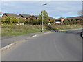
Power Station Road, Stourport-on-Severn
This residential area is commonly referred to as the Power Engine Estate as it was built in the early 1990's on the site of Stourport's former power station. Power Station Road is one of the main roads on the estate.
Image
Image: © P L Chadwick
Taken: 26 Apr 2014
0.05 miles
4
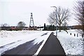
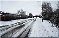
Power Station Road in winter, Stourport-on-Severn
A wintry scene with an electricity pylon in the distance. Just after this the road swings to the left behind it, but a public footpath going off to the right goes down to the River Severn.
Image: © P L Chadwick
Taken: 2 Mar 2018
0.05 miles
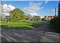
5
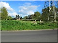
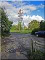
Field adjacent to Power Station Road, Stourport-on-Severn
There is an electricity pylon in one corner of this field, part of which can be seen here.
Image
Image: © P L Chadwick
Taken: 26 Apr 2014
0.07 miles
6
Electricity pylon adjacent to Power Station Road, Stourport-on-Severn
There are a lot of electricity pylons around this residential area, probably a legacy from the days when Stourport's power station was here. Photographed from a public footpath from Power Station Road to the bank of the River Severn.
Image: © P L Chadwick
Taken: 26 Apr 2014
0.08 miles
7
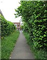
Footpath to Golden Hind Drive, Stourport-on-Severn
The footpath gives access to and from Golden Hind Drive and the fields by the River Severn and the Severn Way long distance footpath. Looking in this direction, the footpath ends at a kissing gate which gives access to Golden Hind Drive.
Image
Image: © P L Chadwick
Taken: 25 May 2015
0.08 miles
8
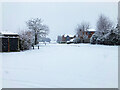
Snow in Resolution Way, Stourport-on-Severn
This is actually a colour photograph but there is virtually no colour to be seen. There had been very heavy snow the previous night and early morning and the sky was very overcast.
Image: © P L Chadwick
Taken: 10 Dec 2017
0.09 miles
9
Snow covered Resolution Way, Stourport-on-Severn, Worcs
A snow covered Resolution Way. On the left is Cutty Sark Drive.
Image: © P L Chadwick
Taken: 24 Jan 2021
0.09 miles
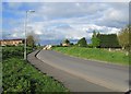
10
Power Station Road, Stourport-on-Severn
Power Station Road is the road in the middle. In the foreground is an access road to houses and this part is the start of a public footpath which leads down to the River Severn. To the left of the houses, on Power Station Road, is Watery Lane, which leads to a caravan site. See also:- Image
Image: © P L Chadwick
Taken: 26 Apr 2014
0.09 miles