IMAGES TAKEN NEAR TO
Parsons Court, STOURPORT-ON-SEVERN, DY13 9GG
Introduction
This page details the photographs taken nearby to Parsons Court, DY13 9GG by members of the Geograph project.
The Geograph project started in 2005 with the aim of publishing, organising and preserving representative images for every square kilometre of Great Britain, Ireland and the Isle of Man.

There are currently over 7.5m images from over14,400 individuals and you can help contribute to the project by visiting https://www.geograph.org.uk
Image Map
Images are licensed for reuse under creativecommons.org/licenses/by-sa/2.0
Notes
- Clicking on the map will re-center to the selected point.
- The higher the marker number, the further away the image location is from the centre of the postcode.
Image Listing (228 Images Found)
Images are licensed for reuse under creativecommons.org/licenses/by-sa/2.0
Image
Details
Distance
1
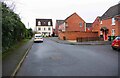
The Spinney, Stourport-on-Severn, Worcs
The Spinney is a modern residential development and a turning off Evergreen Way. Behind the hedge on the left, nearest the camera, is a building which was last used as an off-licence and shop, but in late Victorian times was apparently a brewery. It is currently for sale as a development site and likely to be demolished at some point.
Image: © P L Chadwick
Taken: 21 Feb 2021
0.04 miles
2
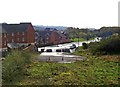
Route of possible Stourport relief road
The road in the distance, Millfields Drive, has been built on the site of part of a former railway line. This branched off the line serving Stourport, and went to the now demolished power station, near the River Severn. The road's present function is to give access to various residential developments.
In the immediate foreground is the site of a possible continuation of this road, which would function as part of a relief road for the town. There is considerable doubt over whether this bit will ever be built. To do so would mean slicing through a section of the remaining green space between Stourport and Kidderminster, and would no doubt generate a huge row.
Image
Image: © P L Chadwick
Taken: 31 Oct 2009
0.04 miles
3
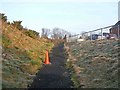
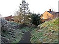
Start of footpath
This photograph shows the footpath where it starts from the new road shown here (approximately opposite the new road known as Evergreen Way): Image At the other end it comes out at the end of Summerfield Road here: Image On its way, it threads its very narrow route around the ends of gardens & what seems to be waste land. Not a path to be taken at night, and indeed one might think twice about walking it in daylight too.
Image: © P L Chadwick
Taken: 28 Dec 2009
0.04 miles
4
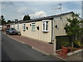
Mill Lane, Stourport
This looks like an old 'prefab'. The houses either side have been rebuilt in a more modern style. I couldn't go past this without taking its photograph.
Image: © Chris Allen
Taken: 19 Jun 2017
0.05 miles
5
Footpath to Summerfield Road
The footpath is about to dive between the fenced back ends of people's gardens and some other fenced land. It's secluded, narrow and rather off-putting. The brick structures which can be seen either side of the path at this point, are undoubtedly connected with the former branch railway line to the demolished power station. It used to come through here, though at a much higher level. So these may have been the bases of pillars of a bridge or other structure. Image
Image: © P L Chadwick
Taken: 28 Dec 2009
0.05 miles
6
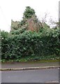
Former off-licence and shop (5), 77 Mill Road, Stourport-on-Severn, Worcs
This is the view of the former off-licence and shop from The Spinney. The vegetation is so out of control that not a great deal can be seen. However there does seem to have been some kind of tower structure, which possibly dates from when the building was used as a brewery in late Victorian times.
More details and links to other photographs, see:- Image
Image: © P L Chadwick
Taken: 21 Feb 2021
0.05 miles
7
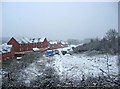
Looking towards a snow-covered Millfields Drive
It was snowing heavily when this photograph was taken from the former railway line to Stourport-on-Severn.
Image
Image: © P L Chadwick
Taken: 18 Dec 2010
0.05 miles
8
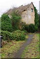
Former off-licence and shop (1), 77 Mill Road, Stourport-on-Severn, Worcs
In late Victorian times the building was a family-run brewery, but later for many years it was an off-licence and shop. It closed in the late 1960's. Currently it is for sale as a redevelopment site. There is no current planning permission in force for the site, but the estate agents handling the sale seem to think that a residential development might be favoured. The building, which includes No. 75 at the western end, is apparently in poor condition and will probably be demolished at some point. It is not listed.
Image
Image
Image
Image
Image: © P L Chadwick
Taken: 21 Feb 2021
0.06 miles
9
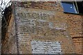
Former off-licence and shop (3) M & B sign, 77 Mill Road, Stourport-on-Severn, Worcs
A very faded Mitchells & Butlers sign can still just about be made out on this wall of the former off-licence & shop. M & B still exist but no longer brew their own beers. Today they concentrate on running public houses, restaurants and the like.
More details and links to other photographs, see:- Image
Image: © P L Chadwick
Taken: 21 Feb 2021
0.06 miles
10
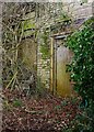
Former off-licence and shop (4) - doors, 77 Mill Road, Stourport-on-Severn, Worcs
Two doors of the former off-licence and shop which closed in the late 1960's.
More details and links to other photographs, see:- Image
Image: © P L Chadwick
Taken: 21 Feb 2021
0.06 miles