IMAGES TAKEN NEAR TO
Walton Close, STOURPORT-ON-SEVERN, DY13 0LS
Introduction
This page details the photographs taken nearby to Walton Close, DY13 0LS by members of the Geograph project.
The Geograph project started in 2005 with the aim of publishing, organising and preserving representative images for every square kilometre of Great Britain, Ireland and the Isle of Man.

There are currently over 7.5m images from over14,400 individuals and you can help contribute to the project by visiting https://www.geograph.org.uk
Image Map
Images are licensed for reuse under creativecommons.org/licenses/by-sa/2.0
Notes
- Clicking on the map will re-center to the selected point.
- The higher the marker number, the further away the image location is from the centre of the postcode.
Image Listing (20 Images Found)
Images are licensed for reuse under creativecommons.org/licenses/by-sa/2.0
Image
Details
Distance
1
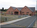
Areley King Village Hall
This new and substantial village hall was built in 2003 according to the stone visible above the entranceway.
Image: © David Stowell
Taken: 13 Aug 2006
0.13 miles
4
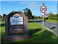
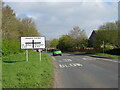
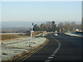
Welcome to Stourport-on-Severn!
The A451 from Great Witley is greeted by this solid sign.
Image: © Peter Whatley
Taken: 3 Jan 2009
0.14 miles
6
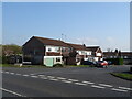
Areley Kings
Looking along the road from the centre of Areley Kings towards Astley Cross.
Image: © David Stowell
Taken: 13 Aug 2006
0.16 miles
7
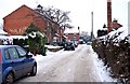
Bowpatch Road, Areley Kings, Stourport-on-Severn
The road is a cul-de-sac off the road known as Areley Commons. Towards its end Bowpatch Road makes a left turn, and then shortly terminates. Image
Image: © P L Chadwick
Taken: 26 Dec 2010
0.16 miles
8
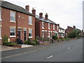
The start of Bowpatch Road, Areley Kings, Stourport-on-Severn
The wall on the left is that of the Areley Kings Pharmacy. The road starts at a junction with the road known as Areley Common, and is a cul-de-sac. It is part of the original village of Areley Kings, and most of the buildings it were built before the massive expansion of Areley Kings in the second half of the 20th century.
Image
Image: © P L Chadwick
Taken: 26 Dec 2010
0.17 miles
9
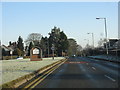
Bewdley Road junction, west of Stourport
The B4194 crosses the A451 at this point and provides an alternative to the customary crawl through the canal town.
Image: © Peter Whatley
Taken: 3 Jan 2009
0.18 miles
10
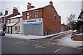
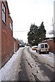
Areley Kings Pharmacy, 38 Areley Common, Areley Kings, Stourport-on-Severn
This pharmacy is on the corner of the road known as Areley Common and Bowpatch Road. There used to be a General Practice surgery in Areley Kings, but currently there isn't one.
Areley Kings was once an independent village to the south of Stourport-on-Severn and the River Severn. Although it still has some village characteristics, it is today much extended with new private estates and a large social housing estate. It is in effect now part of the town of Stourport-on-Severn, and does not have a parish council but elects representatives to the Stourport Town Council.
Image: © P L Chadwick
Taken: 26 Dec 2010
0.19 miles