IMAGES TAKEN NEAR TO
Ironside Close, BEWDLEY, DY12 2HX
Introduction
This page details the photographs taken nearby to Ironside Close, DY12 2HX by members of the Geograph project.
The Geograph project started in 2005 with the aim of publishing, organising and preserving representative images for every square kilometre of Great Britain, Ireland and the Isle of Man.

There are currently over 7.5m images from over14,400 individuals and you can help contribute to the project by visiting https://www.geograph.org.uk
Image Map
Images are licensed for reuse under creativecommons.org/licenses/by-sa/2.0
Notes
- Clicking on the map will re-center to the selected point.
- The higher the marker number, the further away the image location is from the centre of the postcode.
Image Listing (42 Images Found)
Images are licensed for reuse under creativecommons.org/licenses/by-sa/2.0
Image
Details
Distance
1
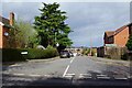
Entrance to Hales Park from Wyre Hill, Bewdley, Worcs
Hales Park is a modern housing estate. Bewdley is a hilly town and this area is at a much higher elevation than the town centre. Fortunately for the local residents there is a bus service through Hales Park, which connects to the town centre.
Image: © P L Chadwick
Taken: 27 Mar 2021
0.04 miles
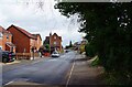
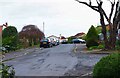
2

Wyre Hill, Bewdley, Worcs
A section of this long road, with its mix of old & new buildings. In this direction it is heading out of town.
Image: © P L Chadwick
Taken: 27 Mar 2021
0.04 miles
3
Wyre Hill, Bewdley, Worcs
Wyre Hill is a very long road which in this direction eventually starts a very steep descent towards the town centre. Its last section is called Sandy Bank and eventually forms a junction with Welch Gate. Wyre Hill is interesting for its mix of modern and very old houses. The steep section can be difficult to negotiate in a car if another vehicle is coming up the hill, because of parked vehicles.
Image: © P L Chadwick
Taken: 27 Mar 2021
0.07 miles
4
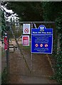
Wyre Hill Play Area (1) - entrance gate, Bewdley, Worcs
This play area is provided and maintained by Bewdley Town Council. It is intended for children up to 14 years old. The entrance gate is near the end of a public footpath from Wyre Hill. It can be reached by other paths, including one from Park Lane. The small collection of notices includes one requesting children to sanitise their hands before and after using the equipment here. This is due to the current Coronavirus pandemic. How many will do this or even bring a bottle of sanitiser is a moot point in my view.
Image
Image
Image
Image: © P L Chadwick
Taken: 27 Mar 2021
0.09 miles
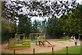
5
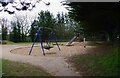
Wyre Hill Play Area (3), Bewdley, Worcs
A swing and a slide in the play area.
Link to other photos:- Image
Image: © P L Chadwick
Taken: 27 Mar 2021
0.09 miles
6
Branches Close, Bewdley, Worcs
Modern residential cul-de-sac off Birch Tree Road.
Image: © P L Chadwick
Taken: 27 Mar 2021
0.10 miles
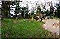
7
Wyre Hill Play Area (2), Bewdley, Worcs
Some of the equipment in the play area seen from the adjacent public footpath from Wyre Hill.
Link to other photos:- Image
Image: © P L Chadwick
Taken: 27 Mar 2021
0.10 miles
8
Wyre Hill Play Area (4), Bewdley, Worcs
Swings and other equipment in the play area.
Link to other photos:- Image
Image: © P L Chadwick
Taken: 27 Mar 2021
0.10 miles
9
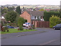
Hales Park Estate, Bewdley
1960's housing looking North across Hales Park estate towards Bark Hill estate (red rooves, right) and The Lakes Estate (centre left). On the 1940's OS Map much of this area was cherry and other fruit orchards. Now all that remain are street names of cherry varieties, Morello Close, Ironside Close, Early River Place, although it is possible to find the occasional old fruit tree in back gardens.
Image: © Richard Greenwood
Taken: 8 Oct 2006
0.11 miles
10
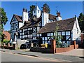
Wyre Court in Bewdley
Dating from the late 16th century with later extensions and alterations. Now converted into apartments. Along Wyre Hill in Bewdley.
Image: © Mat Fascione
Taken: 9 Jul 2022
0.11 miles