IMAGES TAKEN NEAR TO
Summerfield Lane, KIDDERMINSTER, DY11 7SA
Introduction
This page details the photographs taken nearby to Summerfield Lane, DY11 7SA by members of the Geograph project.
The Geograph project started in 2005 with the aim of publishing, organising and preserving representative images for every square kilometre of Great Britain, Ireland and the Isle of Man.

There are currently over 7.5m images from over14,400 individuals and you can help contribute to the project by visiting https://www.geograph.org.uk
Image Map (Loading...)


Getting Data...Please wait
Leaflet Map data © OpenStreetMap
Images are licensed for reuse under creativecommons.org/licenses/by-sa/2.0
Notes
- Clicking on the map will re-center to the selected point.
- The higher the marker number, the further away the image location is from the centre of the postcode.
Image Listing (24 Images Found)
Images are licensed for reuse under creativecommons.org/licenses/by-sa/2.0
Image
Details
Distance
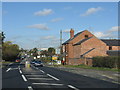
1

Roxel, Kidderminster
Update of https://www.geograph.org.uk/photo/504580 from 2007.
Image: © Mike Dodman
Taken: 17 Sep 2024
0.07 miles
2
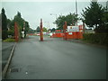
Summerfield Lane, Summerfield
Summerfield Lane comes to an end at the entrance to the Roxel Research Centre, which covers most of this square.
This Anglo-French company makes rocket motors for Cruise missiles.
Image: © planetearthisblue
Taken: 25 Jul 2007
0.09 miles
3
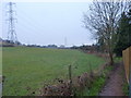
Bridleway from Summerfield towards Summerway Lane
The fencing on the right surrounds the site of the Image, a 'tin tabernacle', which has now been demolished, and the site is being built upon.
Image: © Richard Law
Taken: 14 Dec 2010
0.13 miles
4
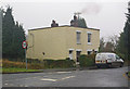
Semis in Summerfield Lane
An unusual pair of semi detached houses, suggesting little imagination on the part of the architect.
Image: © Ian Capper
Taken: 15 Dec 2009
0.14 miles
7
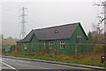
Former St John's Church, Summerfield
A "tin tabernacle" (or more properly an "iron church").
The last service was held at St John's in 1994, shortly before it was badly damaged by strong winds. A planning permission application for demolition and replacement by a house was turned down in 2007, and it remains vacant and unused.
Image: © Ian Capper
Taken: 15 Dec 2009
0.15 miles
9
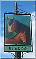
Mare & Colt (2) - sign, Worcester Road, Summerfield
The pub has received this new sign, with a traditional design, in the last couple of years. It had an entirely different one, when photographed by Ian Capper in December 2009:- Image
Image
Image: © P L Chadwick
Taken: 7 Aug 2011
0.16 miles
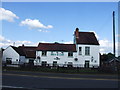
10
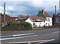
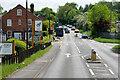
Mare & Colt (1), Worcester Road, Summerfield
This popular food-focused pub is part of the Chef & Brewer chain. It is on the corner of Stanklyn Lane and the busy Worcester Road (the A449). It is very near to Kidderminster and well-placed to catch passing trade, which it successfully does.
Image
Image: © P L Chadwick
Taken: 7 Aug 2011
0.16 miles