
IMAGES TAKEN NEAR TO
Reservoir Road, KIDDERMINSTER, DY11 7AP
Introduction
This page details the photographs taken nearby to Reservoir Road, DY11 7AP by members of the Geograph project.
The Geograph project started in 2005 with the aim of publishing, organising and preserving representative images for every square kilometre of Great Britain, Ireland and the Isle of Man.

There are currently over 7.5m images from over14,400 individuals and you can help contribute to the project by visiting https://www.geograph.org.uk
Image Map
Images are licensed for reuse under creativecommons.org/licenses/by-sa/2.0
Notes
- Clicking on the map will re-center to the selected point.
- The higher the marker number, the further away the image location is from the centre of the postcode.
Image Listing (23 Images Found)
Images are licensed for reuse under creativecommons.org/licenses/by-sa/2.0
Image
Details
Distance
1
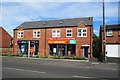
Vets4Pets and Pets Corner, 409 Stourport Road, Kidderminster
Two pet focussed businesses side by side. Vets4Pets is a veterinary surgery, and Pets Corner is the local branch of a chain of family owned pet shops. Upstairs are residential apartments. There is a car park at the back. The building which houses these businesses is new. It is built on the site of the former Park Inn, which was demolished around June 2012.
Image
Image: © P L Chadwick
Taken: 8 Jun 2014
0.08 miles
2
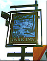
Park Inn (2) - sign, 409 Stourport Road, Kidderminster
The colours have faded, but the sign shows a family having a picnic. Unfortunately the photograph had to be taken into the sun, as the other side of the sign was partially obscured by other signage.
Update June 2012:- The sign has recently gone and the pub has been demolished.
Image
Image: © P L Chadwick
Taken: 16 Oct 2011
0.08 miles
3
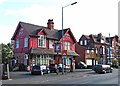
Park Inn (1), 409 Stourport Road, Kidderminster
Not to be confused with the food focused Park Gate Inn on Stourbridge Road, just outside the town. The Park Inn in Stourport Road is very much a local pub. Possibly not for much longer, as currently (October 2011) there is a planning application before the Council to demolish it. The applicant wishes to replace it with a pet shop & veterinary surgery, with two flats (each with two bedrooms) above. If this is passed, not only will it mean 22 car parking spaces, instead of the present six, thus increasing the nightmare traffic on this road, it will also remove one of the last of the few pubs in this area.
Update June 2012: In the last few days this building has been completely demolished to make way for the new development outlined above. At this rate Kidderminster will soon have more veterinary surgeries than dogs!
Image
Update June 2014:- the new building occupied, see: Image
Image: © P L Chadwick
Taken: 16 Oct 2011
0.08 miles
4
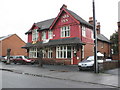
Park Inn, Stourport Road, Kidderminster
Image: © Roger Cornfoot
Taken: 24 Oct 2009
0.09 miles
5
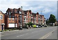
Terrace of housing, Stourport Road, Kidderminster
Stourport Road has a wide variety of housing types along its considerable length. This terrace is still mainly but not exclusively in residential use. Its ends on the corner of Beauchamp Avenue.
Image: © P L Chadwick
Taken: 8 Jun 2014
0.09 miles

8
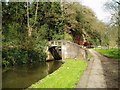
Caldwall Bridge, Staffs.& Worcs. Canal
Caldwall Lock has a split iron bridge to accommodate the rope in days of horse-drawn narrowboats. The sandstone cliff behind the lock is geologically interesting, being the southern tip of a bed of similar rock which stretches some 15 miles north. The picture was taken from grid reference SO 82765 75549.
Image: © Martyn B
Taken: 4 Apr 2005
0.19 miles
9
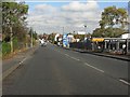
Stourport Road from the railway bridge crest
Image: © Peter Whatley
Taken: 26 Oct 2011
0.19 miles
10
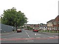
Parry Road, Kidderminster
This road leads off Sutton Park Road, to the Sutton Farm area of Kidderminster. This is a large area of mainly social housing, which was developed from 1929 onwards. Behind the fence on the left, is the site of the demolished Sutton Arms pub, on which a development of detached houses is going to be built.
Image: © P L Chadwick
Taken: 15 Sep 2010
0.22 miles