IMAGES TAKEN NEAR TO
Whitehill Road, KIDDERMINSTER, DY11 6JH
Introduction
This page details the photographs taken nearby to Whitehill Road, DY11 6JH by members of the Geograph project.
The Geograph project started in 2005 with the aim of publishing, organising and preserving representative images for every square kilometre of Great Britain, Ireland and the Isle of Man.

There are currently over 7.5m images from over14,400 individuals and you can help contribute to the project by visiting https://www.geograph.org.uk
Image Map
Images are licensed for reuse under creativecommons.org/licenses/by-sa/2.0
Notes
- Clicking on the map will re-center to the selected point.
- The higher the marker number, the further away the image location is from the centre of the postcode.
Image Listing (29 Images Found)
Images are licensed for reuse under creativecommons.org/licenses/by-sa/2.0
Image
Details
Distance
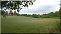
1
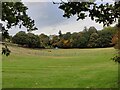
Paddocks on the western edge of Kidderminster
Image: © Mat Fascione
Taken: 9 Oct 2022
0.07 miles
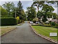
3
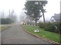
The western end of Whitehill Road in Kidderminster
A private road on the western fringe of the town. Detached houses on both sides, some quite large and impressive, others on a fairly typical scale and also with a fair variety of ages ranging from maybe the 1930's to the 1980's or '90's and styles from 'executive' to 'gin palace' to 'golf-clubhouse-meets-aspirational-suburbia' .
Image: © Jeremy Bolwell
Taken: 12 Dec 2012
0.09 miles
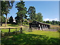
5
Farm land near Sutton Farm, Kidderminster
Looking north from the public footpath near Whitehill Wood. The housing is in Whitehill Road.
Image: © Roger Kidd
Taken: 15 Oct 2020
0.10 miles
6
Whitehill Road at Sutton Park, Kidderminster
Viewed from the public footpath at Rhydd Covert.
Image: © Mat Fascione
Taken: 9 Oct 2022
0.10 miles
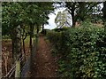
7

The end of Whitehill Road, Kidderminster
The 'road' terminates here. The land ahead is the outer boundary of the well known West Midland Safari Park.
It is a little disconcerting to walk along Whitehill Road on a frosty, foggy December morning and hear, distinctively and repeatedly, and most strikingly, from a matter of a few hundred metres, the roars of a male lion.
Image: © Jeremy Bolwell
Taken: 12 Dec 2012
0.11 miles
8
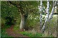
Footpath with trees near Kidderminster, Worcestershire
The public footpath leads from the Rifle Range Nature Reserve towards Rhydd Covert and the safari park. Beyond the field on the right is housing in Whitehill Road.
Image: © Roger Kidd
Taken: 15 Oct 2020
0.13 miles
9
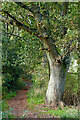
Footpath through Whitehill Wood near Kidderminster, Worcestershire
Looking north-west, the public footpath leads towards Rhydd Covert and the safari park.
Image: © Roger Kidd
Taken: 15 Oct 2020
0.13 miles
10
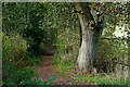
Footpath through Whitehill Wood near Kidderminster, Worcestershire
Looking north-west, the public footpath leads towards Rhydd Covert and the safari park.
Image: © Roger Kidd
Taken: 15 Oct 2020
0.13 miles