IMAGES TAKEN NEAR TO
Fairfield Lane, KIDDERMINSTER, DY11 5QJ
Introduction
This page details the photographs taken nearby to Fairfield Lane, DY11 5QJ by members of the Geograph project.
The Geograph project started in 2005 with the aim of publishing, organising and preserving representative images for every square kilometre of Great Britain, Ireland and the Isle of Man.

There are currently over 7.5m images from over14,400 individuals and you can help contribute to the project by visiting https://www.geograph.org.uk
Image Map
Images are licensed for reuse under creativecommons.org/licenses/by-sa/2.0
Notes
- Clicking on the map will re-center to the selected point.
- The higher the marker number, the further away the image location is from the centre of the postcode.
Image Listing (8 Images Found)
Images are licensed for reuse under creativecommons.org/licenses/by-sa/2.0
Image
Details
Distance
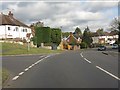
1
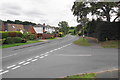
Franche Road
The village has had some early residential expansion in Fairfield. Franche Road is seen here at its junction with Fairfield Lane.
Image: © Bill Boaden
Taken: 14 Sep 2018
0.17 miles
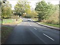
4

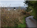
Farmland near Fairfield in Worcestershire
Looking south-west towards Fairfield from the B4189 Shatterford Lane.
Image: © Roger Kidd
Taken: 23 Aug 2021
0.20 miles
6
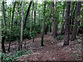
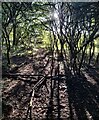
Woodland by Shatterford Lane west of Wolverley
About five hundred metres west of Wolverley village.
Image: © Roger Kidd
Taken: 23 Aug 2021
0.23 miles