IMAGES TAKEN NEAR TO
Audley Drive, KIDDERMINSTER, DY11 5NF
Introduction
This page details the photographs taken nearby to Audley Drive, DY11 5NF by members of the Geograph project.
The Geograph project started in 2005 with the aim of publishing, organising and preserving representative images for every square kilometre of Great Britain, Ireland and the Isle of Man.

There are currently over 7.5m images from over14,400 individuals and you can help contribute to the project by visiting https://www.geograph.org.uk
Image Map (Loading...)


Getting Data...Please wait
Leaflet Map data © OpenStreetMap
Images are licensed for reuse under creativecommons.org/licenses/by-sa/2.0
Notes
- Clicking on the map will re-center to the selected point.
- The higher the marker number, the further away the image location is from the centre of the postcode.
Image Listing (67 Images Found)
Images are licensed for reuse under creativecommons.org/licenses/by-sa/2.0
Image
Details
Distance
1
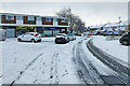
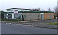
Shops on Audley Drive
Part of the Ferndale Estate in Kidderminster.
Image: © Mat Fascione
Taken: 24 Jan 2021
0.04 miles
2
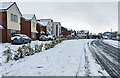
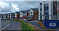
Eagles Place on Coningsby Drive
The houses have been built on the site of the demolished Eagles Nest public house, in the Ferndale Estate area of Kidderminster.
Image
Image: © Mat Fascione
Taken: 24 Jan 2021
0.05 miles
3
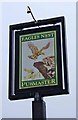
The former Eagles Nest pub sign, Coningsby Drive, Kidderminster
The Eagles Nest was part of the Pubmaster chain and closed in 2008. The pub sign currently is still in place, on top of a pole, by the side of the large car park adjacent to Coningsby Drive. Planning permission has been given for demolition of the pub and for residential redevelopment. See also Image Image and for a view when the pub was open Image
Image: © P L Chadwick
Taken: 29 Nov 2008
0.05 miles
4
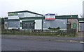
The former Eagles Nest, Coningsby Drive, Kidderminster
A dull Winter's day enhances the depressing impression given by this former public house, which closed in 2008. Despite the sign "Under New Management", this is unlikely to re-open, as the Council gave permission for its demolition and replacement by housing. It was the only public house actually in the Ferndale area of the town and despite a petition against closure signed by over 200 people, the Council made their decision. Now that the housing market is in serious collapse, it is difficult to imagine developers falling over themselves to build on here in the near future. Local residents are likely therefore to have this boarded-up eye-sore on their doorsteps for a long time to come. See also Image and Image
Image: © P L Chadwick
Taken: 29 Nov 2008
0.05 miles
5
The former Eagles Nest, Coningsby Drive, Kidderminster
The Eagles Nest was a typical post-World War II estate pub, situated in the middle of the Ferndale area, on the edge of Kidderminster. The sign "Freehold Development Opportunity" says it all. The Council have given permission for the demolition of the pub and replacement by housing. The large car park to the right of the pub gives plenty of space for the redevelopment. When the pub was open, it looked like this: Image
Image: © P L Chadwick
Taken: 29 Nov 2008
0.06 miles
6
Eagles Place on Coningsby Drive, Kidderminster
Built on the site of the demolished Eagles Nest public house.
Image: © Mat Fascione
Taken: 6 Sep 2020
0.06 miles
7
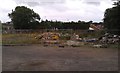
The site of the former Eagles Nest public house
See Image for the pub in happier times, and Image shortly after it closed. The pub was located on Coningsby Drive on the Ferndale Estate. This site and the large adjacent car park will soon be housing.
Image: © Mat Fascione
Taken: 27 Aug 2012
0.06 miles
8
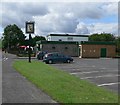
Eagles Nest
Public House on Coningsby Drive in Ferndale, Kidderminster.
Image: © Mat Fascione
Taken: 14 Jul 2007
0.07 miles
10
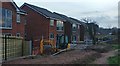
New housing on Coningsby Drive, Kidderminster
Built on the site of the demolished Eagles Nest public house.
Image
Image: © Mat Fascione
Taken: 26 Dec 2018
0.07 miles