IMAGES TAKEN NEAR TO
Baskerville Road, KIDDERMINSTER, DY10 2YF
Introduction
This page details the photographs taken nearby to Baskerville Road, DY10 2YF by members of the Geograph project.
The Geograph project started in 2005 with the aim of publishing, organising and preserving representative images for every square kilometre of Great Britain, Ireland and the Isle of Man.

There are currently over 7.5m images from over14,400 individuals and you can help contribute to the project by visiting https://www.geograph.org.uk
Image Map (Loading...)


Getting Data...Please wait
Leaflet Map data © OpenStreetMap
Images are licensed for reuse under creativecommons.org/licenses/by-sa/2.0
Notes
- Clicking on the map will re-center to the selected point.
- The higher the marker number, the further away the image location is from the centre of the postcode.
Image Listing (39 Images Found)
Images are licensed for reuse under creativecommons.org/licenses/by-sa/2.0
Image
Details
Distance
3
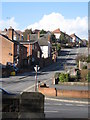
Sion Hill, Kidderminster, Worcs
A 10% grade hill
Image: © Richard Rogerson
Taken: 20 Feb 2010
0.13 miles
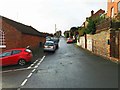
4
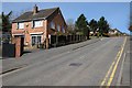
Sion Hill
Sion Hill, a road off Stourbridge Road, leading to Wolverley.
Image: © Philip Halling
Taken: 5 Apr 2018
0.17 miles
5
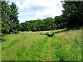
Path on the edge of Springfield Park
This is one of the many paths in and near to Springfield Park, which is owned and managed by Wyre Forest District Council.
Image: © P L Chadwick
Taken: 13 Jun 2009
0.17 miles
6
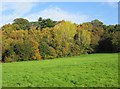
Trees at edge of field, Springfield Park, Kidderminster
It's never been quite clear whether this field is actually in the park or not, but to all intents and purposes it seems to be, as there is a public footpath across it and people, with or without their dogs, wander all over it.
Image: © P L Chadwick
Taken: 13 Nov 2013
0.17 miles
7
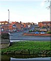
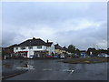
Sion Hill, Broadwaters
Sion Hill is one of the main roads in the Broadwaters area of Kidderminster. In the foreground is Stourbridge Road and the car park of The Hare & Hounds public house.
Image: © P L Chadwick
Taken: 7 Dec 2008
0.18 miles
8
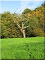
Dead tree at edge of field, Springfield Park, Kidderminster
This old tree seems to have given up the ghost sadly.
Image: © P L Chadwick
Taken: 13 Nov 2013
0.19 miles
9
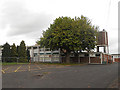
Pitt Street, Broadwaters, Kidderminster
Pitt Street is mainly residential and not a through road. It is connected with the rest of the town by Chapel Hill, which is the road on the left. By the junction is the Broadwaters Methodist Church.
Image: © P L Chadwick
Taken: 6 Dec 2015
0.20 miles
10
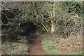
Footpath to the Sports Ground, Springfield Park, Kidderminster, Worcs
This footpath branches off a footpath crossing an adjacent field and leads to the Sports Ground in Springfield Park.
Image
Image: © P L Chadwick
Taken: 15 Jan 2023
0.21 miles