IMAGES TAKEN NEAR TO
Hurcott Road, KIDDERMINSTER, DY10 2PB
Introduction
This page details the photographs taken nearby to Hurcott Road, DY10 2PB by members of the Geograph project.
The Geograph project started in 2005 with the aim of publishing, organising and preserving representative images for every square kilometre of Great Britain, Ireland and the Isle of Man.

There are currently over 7.5m images from over14,400 individuals and you can help contribute to the project by visiting https://www.geograph.org.uk
Image Map
Images are licensed for reuse under creativecommons.org/licenses/by-sa/2.0
Notes
- Clicking on the map will re-center to the selected point.
- The higher the marker number, the further away the image location is from the centre of the postcode.
Image Listing (65 Images Found)
Images are licensed for reuse under creativecommons.org/licenses/by-sa/2.0
Image
Details
Distance
5
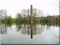
Stack Pool, Kidderminster
The chimney built at the edge of the pool can be identified on the 1:25,000 map as the small dot on the north bank of the main pool. Picture taken from SO 83389 77754.
Image: © Martyn B
Taken: 12 Apr 2005
0.10 miles
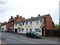
9
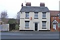
The former Horsefair pub, 2 Stourbridge Road
Now residential accommodation, this was until a few years ago The Horsefair, one of the public houses in the Horsefair area. The area is one of several deprived areas in Kidderminster, but this one is now undergoing regeneration. Meanwhile the area has more than its fair share of problems. Which brings to mind something someone once wrote on the internet about Kidderminster pubs, "You need to know your pubs in Kiddy to avoid a black eye and a thick ear. Some are seriously rough. Get it wrong and it could hurt a lot...." That's probably sound advice and one or two of the town centre pubs, and those on the more run down estates, are probably best avoided.
Another view of the former Horsefair: Image
Image: © P L Chadwick
Taken: 1 Jan 2009
0.11 miles
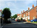
10
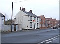
The former Horsefair pub, 2 Stourbridge Road
This area of Kidderminster is known as Horsefair and the pub took its name after this. The area is generally quite run down with a higher than average crime rate. A lot of regeneration is going on and the new housing to the right of the former pub is part of this. The pub is now residential accommodation and at the time the photo was taken the first floor flat was to let.
Image: © P L Chadwick
Taken: 1 Jan 2009
0.11 miles