IMAGES TAKEN NEAR TO
Windsor Drive, KIDDERMINSTER, DY10 2NB
Introduction
This page details the photographs taken nearby to Windsor Drive, DY10 2NB by members of the Geograph project.
The Geograph project started in 2005 with the aim of publishing, organising and preserving representative images for every square kilometre of Great Britain, Ireland and the Isle of Man.

There are currently over 7.5m images from over14,400 individuals and you can help contribute to the project by visiting https://www.geograph.org.uk
Image Map
Images are licensed for reuse under creativecommons.org/licenses/by-sa/2.0
Notes
- Clicking on the map will re-center to the selected point.
- The higher the marker number, the further away the image location is from the centre of the postcode.
Image Listing (160 Images Found)
Images are licensed for reuse under creativecommons.org/licenses/by-sa/2.0
Image
Details
Distance
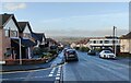
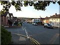
2
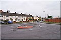
Roundabout, Stoney Lane, Kidderminster
A residential area tucked away near the edge of the town.
Image: © P L Chadwick
Taken: 10 Mar 2013
0.10 miles
3
Entrance to St. Mary's Church of England (VA) Primary School, Stoney Lane, Kidderminster
This is also the entrance to Rainbow Children's Centre, which is a SureStart Children's Centre.
Image
Image: © P L Chadwick
Taken: 10 Mar 2013
0.10 miles
6

St. Mary's Church of England (VA) Primary School, Stoney Lane, Kidderminster
St. Mary's is a fairly recent voluntary aided Church of England primary school. It is in an area where there has been a lot of new housing development, much of it replacing what were previously industrial sites.
Image
Image: © P L Chadwick
Taken: 10 Mar 2013
0.11 miles

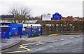
8
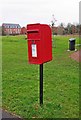
Elizabeth II post-mounted postbox, Stourvale Drive, Kidderminster
This fairly recent postbox is opposite Waterside Grange, and serves the new residential developments in the area. Behind it is the new play area.
Postbox number:- DY10 57. Post code:- DY10 2LA. Last collection:- 5 pm Monday to Friday; 11.30 am Saturday.
The postbox can also be seen in this view:- Image
Image: © P L Chadwick
Taken: 10 Mar 2013
0.12 miles
9
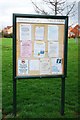
Friends of Springfield Park notice board, near Stourvale Drive, Kidderminster
Friends of Springfield Park, also known as FoSP, were established in 2009, and are a small group of local people working with the council, and other partners to improve the park.
Image: © P L Chadwick
Taken: 12 Apr 2015
0.13 miles
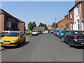
10
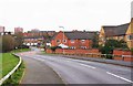
Stourvale Drive, Kidderminster
Looking towards the roundabout at the junction with Stoney Lane.
Image
Image: © P L Chadwick
Taken: 10 Mar 2013
0.13 miles