IMAGES TAKEN NEAR TO
Harold Evers Way, KIDDERMINSTER, DY10 2HG
Introduction
This page details the photographs taken nearby to Harold Evers Way, DY10 2HG by members of the Geograph project.
The Geograph project started in 2005 with the aim of publishing, organising and preserving representative images for every square kilometre of Great Britain, Ireland and the Isle of Man.

There are currently over 7.5m images from over14,400 individuals and you can help contribute to the project by visiting https://www.geograph.org.uk
Image Map (Loading...)


Getting Data...Please wait
Leaflet Map data © OpenStreetMap
Images are licensed for reuse under creativecommons.org/licenses/by-sa/2.0
Notes
- Clicking on the map will re-center to the selected point.
- The higher the marker number, the further away the image location is from the centre of the postcode.
Image Listing (60 Images Found)
Images are licensed for reuse under creativecommons.org/licenses/by-sa/2.0
Image
Details
Distance
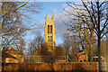
1
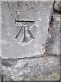
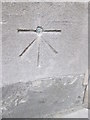
Ordnance Survey Cut Mark
This OS cut mark can be found on the north side of Coventry Road. It marks a point 60.067m above mean sea level.
Image: © Adrian Dust
Taken: 23 Nov 2015
0.05 miles
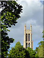
2
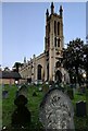
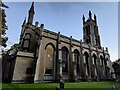
St George's Church in Kidderminster
This large sandstone church was built in the Commissioners' Perpendicular style in 1821/22. The interior was destroyed by fire in 1922 and rebuilt by Sir Giles Gilbert Scott in 1923/25. It is Grade II listed and located on Radford Avenue in Kidderminster.
Image: © Mat Fascione
Taken: 6 Oct 2022
0.07 miles
3
St George's Church in Kidderminster
This large sandstone church was built in the Commissioners' Perpendicular style in 1821/22. The interior was destroyed by fire in 1922 and rebuilt by Sir Giles Gilbert Scott in 1923/25. It is Grade II listed and located on Radford Avenue in Kidderminster.
Image: © Mat Fascione
Taken: 6 Oct 2022
0.07 miles
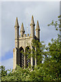
4
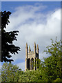
St George's Church tower in Kidderminster, Worcestershire
A telephoto assisted image from the Ringway, looking across St George's Park.
Image: © Roger D Kidd
Taken: 31 May 2015
0.08 miles
5
St George's Church tower in Kidderminster, Worcestershire
A telephoto assisted image from the Ringway, looking across St George's Park.
Image: © Roger D Kidd
Taken: 31 May 2015
0.08 miles
6
St George's Church tower in Kidderminster, Worcestershire
A telephoto assisted image from the Ringway, looking across St George's Park.
Image: © Roger D Kidd
Taken: 31 May 2015
0.08 miles
7
St George's Church in Kidderminster
This large sandstone church was built in the Commissioners' Perpendicular style in 1821/22. The interior was destroyed by fire in 1922 and rebuilt by Sir Giles Gilbert Scott in 1923/25. It is Grade II listed and located on Radford Avenue in Kidderminster.
Image: © Mat Fascione
Taken: 6 Oct 2022
0.08 miles
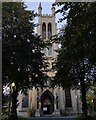
8
St George's Church, Kidderminster
This is the view across St George's Park to the tower of St George's Church. The church, designed by Francis Goodwin, was built and consecrated in 1824 and rebuilt in 1922 following a fire. It is one of the 'Commissioners'' or 'Waterloo' churches built with money voted by Parliament as a result of the Church Buildings Acts of 1818 and 1824.
Image: © Stephen McKay
Taken: 27 Jan 2022
0.08 miles
9
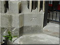
Ordnance Survey 1GL Bolt
This OS Bolt can be found on the SW face of St George's Church. It marks a point 57.656m above mean sea level.
Image: © Adrian Dust
Taken: 23 Nov 2015
0.08 miles
10
Ordnance Survey bolt on St George's Church
This Ordnance Survey bench mark with bolt was established during the First primary levelling of England & Wales, and was levelled (between September 1849 and November 1855) with a height of 189.4580 feet [57.7468 metres] above mean sea level (Liverpool datum). It was included on the Worcester to Aberystwyth (Branch Levelling from Stourport to Kidderminster) levelling line. The surveyor's description was "Bolt in West face of St. George's Church; 2.01 ft. above surface." (page 558)
Image: © Shantavira
Taken: 25 May 2013
0.08 miles